

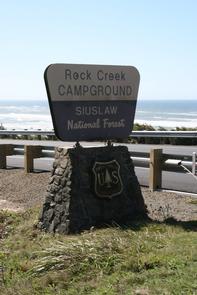

Directions
From Yachats, Oregon, take Highway 101 south about 10 miles. Look for campground sign and turn left.
Phone
541-547-5219
Activities
CAMPING, FISHING, HIKING, WILDLIFE VIEWING, BERRY PICKING, BIRDING
Keywords
ROOR,ROCK CREEK SIUSLAW,SIUSLAW NF – FS,ROCK CREEK CAMPGROUND
Related Link(s)
Overview
Rock Creek Campground is nestled in a grove of large spruce and Douglas fir trees, near a beach on the Oregon Coast. Visitors enjoy relaxing on the beach, admiring colorful sunsets and hiking many trails in the area.
Recreation
Rock Creek offers great birding and fishing opportunities. Anglers cast for cutthroat trout and salmon. The beach and a day-use parking area can be accessed within a half-mile from the campground.
The Rock Creek Wilderness Area, within the Siuslaw National Forest, encompasses about 7,500 acres. The area is comprised of a dense coniferous rainforest, where bigleaf maple and red alder trees line the creeks, and rhododendrons dot the forest floor.
Facilities
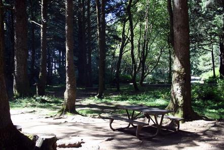
The campground offers single-family sites situated along Rock Creek. Each site is equipped with a picnic table and campfire ring. Vault toilets and drinking water are provided. No electric hookups are available.
Natural Features
Campsites are situated along Rock Creek, just off the Pacific Coast of Oregon in the Siuslaw National Forest, where mosses drape the branches and ferns cover the forest floor, lending a rain forest appearance. The Siuslaw stretches from the lush forests of the coastal mountains to the Oregon Dunes and beaches of the Pacific. Siuslaw is one of only two national forests that border the Pacific Ocean.
The campground’s close proximity to the beach provides opportunities to view awe-inspiring Pacific sunsets, which often leave lasting impressions on visitors. A variety of wildlife can often be viewed on the coast, including pelicans and other shorebirds, sea lions and migrating whales.
Nearby Attractions
The Cape Perpetua Visitor Center is a few miles north. The center has a phenomenal view of the ocean. A variety of short film are shown in the theater, and whale watch volunteers are posted in March to help visitors spot the beautiful, migrating creatures.
Visitors also enjoy exploring tide pools at Cape Perpetua, and hiking along the area’ 23-mile trail system. Several paths lead through dense, old-growth forests and to rocky coastal overlooks.