CAGLE RECREATION AREA, TX Campground Reservation, Info, Images, Map, Directions

CAGLE RECREATION AREA, Texas Campground Images, Info & Reservations

Directions

From Huntsville, Texas, take I-45 to mile marker 103, New Waverly exit, and go to the first stop sign. Do not turn; stay straight on the feeder until you reach the stop sign at FM 1375. Turn right (west) on FM 1375. The Sam Houston District Office is on the right approximately 2.5 miles west of I-45. Cagle Recreation Area is approximately 6 miles west of I-45 and approximately 3 miles west of the District Office on the left hand side of FM 1375.

From Conroe, Texas, take I-45 to mile marker 102, New Waverly exit, and go to the first stop sign. Turn left (west) on FM 1375. The Sam Houston District Office is on the right approximately 2.5 miles west of I-45. Cagle Recreation Area is approximately 6 miles west of I-45 and approximately 3 miles west of the District Office on the left hand side of FM 1375.

Phone

936-344-6205

Activities

BIKING, BOATING, CAMPING, FISHING, HIKING, WATER SPORTS

Keywords

CAGL,NFs IN TEXAS -FS

Related Link(s)

Rec Area Info & Images

Texas State Road Conditions

Texas State Tourism

Overview

Cagle Recreation Area is a popular campground and day-use area that sits along the shoreline of Lake Conroe on the west fork of the San Jacinto River, just 1 hour north of Houston, Texas. The area offers great camping, fishing, hiking, hunting, birding and water sports year-round.

Recreation

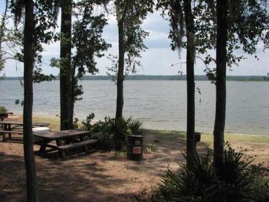
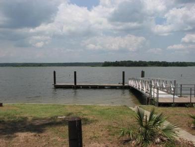
Anglers are drawn to the 22,000-acre Lake Conroe for its forested lake shore and open water. The lake is particularly noted for black bass and year-round fishing. Swimming is not allowed, but fishing, hiking, picnicking and shoreline wading are sure to provide plenty of fun for kids. Hikers and mountain bikers can try the 2-mile Cagle Trail within the facility. Learn more about recreation in the national forest.

Facilities

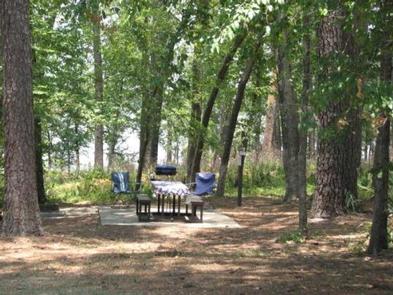
The campground offers sites with full-service hookups organized into two loops. Each loop has sites overlooking Lake Conroe and restrooms with flush toilets, sinks and hot showers. The facility also has a boat ramp with large parking area, hiking and bicycle trails and a picnic area overlooking the lake.

Natural Features

Cagle is nestled among the pines of the Sam Houston National Forest. This area is covered with beautiful large pine and hardwood trees plus thousands of colorful wildflowers. Mid-February redbud tree blossoms followed by dogwood blossoms in early March put on a spectacular display of flowers.

Lake Conroe and the surrounding forest provide wintering habitat for the endangered bald eagle.

Temperatures are moderate to cool from September through May, and hot and humid from June to August. Winters are cool and wet.

Nearby Attractions

Visitors can explore the national forest’s 85 miles of off-road vehicle, equestrian and mountain bike trails. The 128 mile Lone Star Hiking trail is nearby with a portion of the trail located near Lake Conroe.

Reservation

More from CampingHiking.net:

SAGE HILL, California Campground Images, Info & Reservations

Directions From highway 101, take highway 154 approximately 15 miles to paradise road. Turn right and continue 5 miles to Los Prietos road. Turn left past the ranger station to the camp entrance. Phone 805-434-1996 Activities CAMPING, FISHING, HIKING, HORSEBACK RIDING, HUNTING, SWIMMING SITE Keywords SAGE,SANTA YNEZ RECREATION AREA,LOS PADRES

MOUNT RYNDA CABIN, Alaska Campground Images, Info & Reservations

Directions Accessible by shallow draft boat and float plane during moderate to high river levels, 18 miles from Wrangell. Low river levels limit small boat access as the Andrews Creek entrance becomes blocked. Tides may affect access; consult local tide tables. A tide of 14 feet or higher is needed

NORTH SANDUSKY CAMPGROUND, Illinois Campground Images, Info & Reservations

Directions From I-57 take exit 77 and turn west on Route 154. After 4.5 miles turn south onto Rend City Road. Continue through the four-way stop and follow signs to the campground. Phone 618-724-2493 Activities BOATING, CAMPING, FISHING, SWIMMING SITE Keywords NSAN,REND LAKE,NORTH SANDUSKY,THE SANDUSKYS,PINTAIL,RINGNECK,WOODUCK,SHAGBARK,MAPLE,SWEETGUM,HICKORY,WHITE OAK,DUCK LOOPS,BY COY & WILMA’S

LAKE FORK CAMPGROUND, Colorado Campground Images, Info & Reservations

Directions Lake Fork campground is located off of Hwy 50 between Gunnison and Montrose, along Blue Mesa reservoir. Phone 970-641-2337 Activities BIKING, BOATING, CAMPING, FISHING, HIKING, HUNTING, WATER SPORTS, WILDLIFE VIEWING, SWIMMING SITE Keywords LAFO,CURECANTI NATIONAL RECREATION,CURECANTI Related Link(s) Rec Area Info & Images Colorado State Road Conditions Colorado State

APGAR GROUP SITES, Montana Campground Images, Info & Reservations

Directions Located 1 mile northeast of the west entrance near West Glacier, Montana. Access is from U.S. Highway 2, approximately 32 miles northeast of Kalispell, Montana. Phone 406-888-7800 Activities BIKING, BOATING, CAMPING, INTERPRETIVE PROGRAMS, FISHING, HIKING, VISITOR CENTER, WILDLIFE VIEWING, DAY USE AREA, SWIMMING SITE Keywords Apgar Campground,Apgar,Glacier,Glacier National Park,APGAR

LAKELAND PAVILION, Texas Campground Images, Info & Reservations

Directions While traveling East on US Highway 380, turn right (South) on State Highway 78 at Farmersville. Go South about 4 miles to CR 550. Turn right on CR 550 and continue about 2 miles to the entrance of the park. The pavilion is inside Lakeland Park. Phone 972-442-3141 Activities