MANZANITA LAKE, CA Campground Reservation, Info, Images, Map, Directions

MANZANITA LAKE, California Campground Images, Info & Reservations

Listen

Directions

From Redding, California drive 48 miles east on State Highway 44. Turn right into Lassen Volcanic National Park and continue one mile south to Manzanita Lake Campground.

Phone

530 595-6121

Activities

BOATING, HISTORIC & CULTURAL SITE, CAMPING, INTERPRETIVE PROGRAMS, FISHING, HIKING, PICNICKING, VISITOR CENTER, DAY USE AREA, SWIMMING SITE

Keywords

MANL,Lassen Volcanic National Park

Related Link(s)

Rec Area Info & Images

California State Tourism

California State Road Conditions

Overview

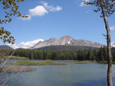
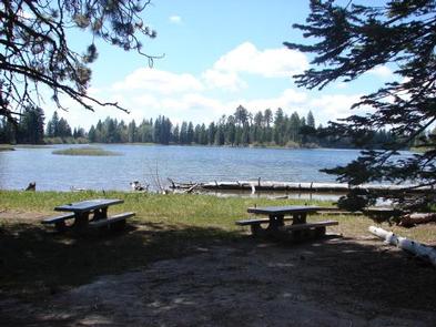
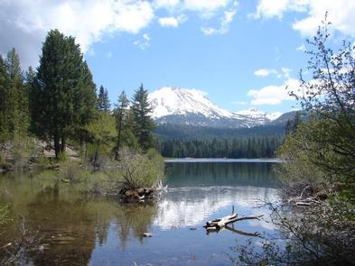
Manzanita Lake Campground (elevation 5,900 ft.) is the largest campground in Lassen Volcanic National Park. It is within walking distance of the scenic Manzanita Lake, a popular fishing and family destination, and offers impressive views of Lassen Peak, the largest volcano in the park at 10,457 feet.

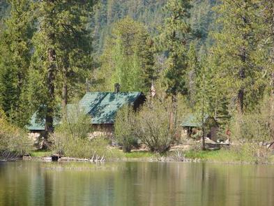
The facility is conveniently located one mile south of the park entrance, close to The Loomis Museum, Loomis Ranger Station and popular hiking trails. Educational programs are presented at the museum and amphitheater.

Recreation

Manzanita Lake is popular with fly fishermen, but the campground does maintain a catch-and-release policy. Non-motorized boating is also permitted and Kayak rentals are available nearby. The park boasts more than 150 miles of hiking trails, a variety of which can be accessed from the campground, including family-friendly hikes as well as those for more experienced hikers.

Facilities

Manzanita Lake Campground is forested with Jeffrey and Ponderosa pines and has many comforts in the campground or close by, including pay showers, a general store and paved roads.

Flush toilets and running water are turned on during the summer, vault toilets are available outside of the peak season. For more information visit Campgrounds of Lassen Volcanic.

Natural Features

The national park is known for its volcanic history, as well as its diversity of plants and animals. It contains 300 active volcanic domes, as well as many hydrothermal features, such as mud pots and steam vents. Lassen Peak is the southernmost active volcano in the Cascades, and the second most recent to erupt in the lower 48 of the United States before Mount Saint Helens.

Lassen National Park boasts over 700 species of flowering plants and 250 species of birds, mammals, reptiles and fish. The park is at the junction of the Cascade Mountains, the Sierra Nevada Mountains and the Great Basin, thus providing many unique habitats.

Reservation

More from CampingHiking.net:

LAKE VESUVIUS RECREATION AREA, Ohio Campground Images, Info & Reservations

Listen Directions From U.S. Highway 52 at Ironton, take State Route 93 north for less than 10 miles to Lake Vesuvius Road (County Road 29). Turn east toward Lake Vesuvius and travel 1 mile to the recreation area. Phone 740-534-6500 Activities BOATING, CAMPING, FISHING, HIKING, PICNICKING, WILDLIFE VIEWING, DAY USE

OGDEN GROUP, Oregon Campground Images, Info & Reservations

Listen Directions From Bend, drive south on Highway 97 for 22 miles. Head east on Road 21 for 3 miles. Ogden Group is on the left. Phone 541-383-5300 Activities CAMPING Keywords OGDE,DESCHUTES NF – FS Related Link(s) Rec Area Info & Images Forest Service Concessionaire Oregon State Tourism Oregon State

GRAYS MEADOWS, California Campground Images, Info & Reservations

Listen Directions Grays Meadows is 6 miles west of the town of Independence, California. Take U.S. Highway 395 to Independence. Turn west on Market Street (which turns into Onion Valley Road) and follow for 6 miles. The first gate accesses sites 36-52. The second gate is 0.25 miles up the

CARNERO GUARD STATION, Colorado Campground Images, Info & Reservations

Listen Directions Carnero Guard Station may be reached by traveling south on Highway 285 approximately 15 miles south of Saguache to the La Garita turnoff (Road G). In La Garita proceed west on County Road 41G for approximately 17 miles. Look for the cabin on the right. NOTE: Forest Road

PINE ISLAND GROUP AREA, Wyoming Campground Images, Info & Reservations

Listen Directions Located 27 miles west of Dayton, Wyoming, on U.S. Highway 14. Phone 406-587-9054 Activities BIKING, BOATING, CAMPING, FISHING, HIKING, WILDLIFE VIEWING Keywords PIIS,PINE ISLAND,BIGHORN NF – FS Related Link(s) Rec Area Info & Images Overview Pine Island Group Area is located along the Bighorn Scenic Byway (U.S. Highway

HORSFALL SAND CAMPING, Oregon Campground Images, Info & Reservations

Listen Directions From North Bend Oregon, travel north on Highway 101 for 1 1/2 miles to Trans Pacific Parkway. Turn west (left) on Trans Pacific Pkwy, proceed 1 mile and turn right onto Horsfall Beach Road. For access via Horsfall Campground drive ½ mile on Horsfall Beach Road, the campground