

Directions
Carnero Guard Station may be reached by traveling south on Highway 285 approximately 15 miles south of Saguache to the La Garita turnoff (Road G). In La Garita proceed west on County Road 41G for approximately 17 miles. Look for the cabin on the right.
NOTE: Forest Road 41G leading to the cabin is unimproved but may be traveled by passenger car, weather permitting. The cabin may also be accessed from Highway 114 west of Saguache, also on Forest Road 41G. During winter months, the cabin may be accessible only by snowmobile, skis or snowshoes.
Phone
719-655-2547
Activities
BIKING, CAMPING, FISHING, HIKING, HUNTING, WINTER SPORTS, WILDLIFE VIEWING
Keywords
CARN,CARNERO CABIN,RIO GRANDE NF- FS,CGS
Related Link(s)
Colorado State Road Conditions
Overview
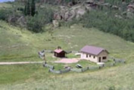
Carnero Guard Station is situated in a high open meadow surrounded by forest at an elevation of 9,840 feet. The high-elevation cabin is located in the north-central area of the San Luis Valley in the Rio Grande National Forest.
The guard station was first proposed in 1907 by the Cochetopa National Forest, and was originally named the John Smith Ranger Station after a homesteader who built a cabin near the site, but never filed on the land. Construction on the cabin began in 1908 and the name was changed to the Carnero Guard Station in 1916.
Recreation
The cabin is a good base camp for hunting, and fishing, which is available at several creeks within a short drive. The area also offers many opportunities for hiking and off-road vehicle adventures in summer, and cross country skiing and snowmobiling in the winter.
There is an off-road vehicle trail about 10 miles southwest of the cabin that travels to within 2 miles of the La Garita Wilderness.
Elk, deer, and other wildlife are often seen in meadows adjacent to the cabin, and moose have been spotted in the Moon Pass area, about 5 miles west.
Facilities
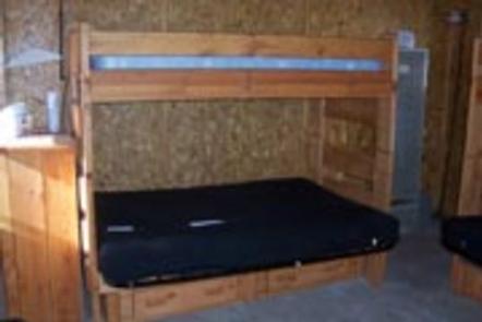
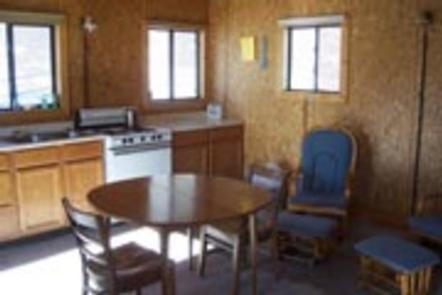
The two-room cabin is furnished with four bunk beds (the top bunk is a single bed, the bottom is a fold-out futon couch that sleeps two) and can accommodate up to 12 people. The cabin has a stove, refrigerator, heater and lighting, all powered with propane. The kitchen is equipped with a table and chairs, cooking utensils and some pots and pans. A picnic table, fire pit and an outdoor vault toilet are also on site. There is no electricity at the cabin, however water is available by an outside hand pump. Water is also available at the Saguache Ranger District Office during business hours from May through November.
Natural Features
Volcanic rock outcroppings dot the forested hillsides and wide pastures near the cabin. The La Garita Wilderness is located approximately 20 miles west of the guard station and features about 35 miles of the Continental Divide well above the timberline.
This area also provides habitats for large herds of elk and mule deer, and on the southern slopes, there is an ancient forest of towering spruce and fir. It is a landscape of rushing streams, broad and gentle alpine meadows, beaver ponds, long talus slopes and tremendous mountain beauty.
Nearby Attractions
Guests at Carnero Guard Station are a short drive from Penitente Canyon, which has become a great draw for rock climbing.