MINERAL LAKE, WI Campground Reservation, Info, Images, Map, Directions

MINERAL LAKE, Wisconsin Campground Images, Info & Reservations

Directions

From Mellen, Wisconsin, take County Highway GG west for about 9 miles to the campground sign. Turn right and drive less than a mile to the campground.

From Clam Lake, Wisconsin, take County Highway GG north for about 9 miles to the campground sign and turn left.

Phone

715-264-2511

Activities

BIKING, BOATING, CAMPING, FISHING, HIKING, WILDLIFE VIEWING

Keywords

MILK,CHEQUAMEGON-NICOLET NF – FS

Related Link(s)

Rec Area Info & Images

Wisconsin State Tourism

Wisconsin State Road Conditions

Overview

We apologize, this campground is currently closed.

Recreation

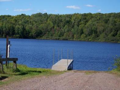
Boating, swimming and fishing are popular activities among visitors. A boat ramp to the lake is provided off of Forest Service Road 187, about a mile from the campground.

Anglers can expect a catch of a variety of freshwater lake and river species, including musky, bass, walleye and pan fish. Eagle watching is also a popular pastime.

The forest is home to hundreds of miles of off-road vehicle, hiking and mountain biking trails, as well as numerous lakes, ponds and rivers to sink a line or launch a boat. Access to the North Country National Scenic Trail, which traverses thousands of miles from New York to North Dakota, is available nearby.

Facilities

Natural Features

The 256-acre Mineral Lake is surrounded by a mixed hardwoods forest. Several campsites overlook the lake and the area is home to a variety of birds, including eagles, and plentiful wildlife.

Nearby Attractions

Morgan Falls and St. Peter’s Dome, the highest peak in the forest, are both located nearby and make excellent day trips.

Reservation

More from CampingHiking.net:

BANDY CREEK, Tennessee Campground Images, Info & Reservations

Directions For detailed directions, please visit: http://www.nps.gov/biso/planyourvisit/directions.htm Phone (423) 286-7275 Activities BIKING, CAMPING, INTERPRETIVE PROGRAMS, FISHING, HIKING, HORSEBACK RIDING, HUNTING, PICNICKING, VISITOR CENTER, WILDLIFE VIEWING, DAY USE AREA, PHOTOGRAPHY, SWIMMING, MOUNTAIN BIKING, KAYAKING, STAR GAZING, BIRDING, NON-MOTORIZED BOATING, EVENING PROGRAMS, RAFTING, BACKPACKING, AMPHITHEATER, ACCESSIBLE SWIMMING Keywords CG02,BANDY,BIG SOUTH FORK NATIONAL

TALL CHIEF COVE, Oklahoma Campground Images, Info & Reservations

Directions From Tulsa, Oklahoma, take Highway 75 north to State Highway 20. Take the Skiatook exit, turn west on State Highway 20 and drive about 15 miles. Turn left on Lake Road and proceed about five miles to the campground. Phone 918-288-6820 Activities BOATING, CAMPING, FISHING, DAY USE AREA, SWIMMING

MAGRUDER RANGERS HOUSE, Montana Campground Images, Info & Reservations

Directions From Darby, Montana, travel south on Highway 93 for 4 miles to West Fork Road/Highway 473. Continue on this road for approximately 14 miles to the Nez Perce Road/Magruder Corridor Road and go another 34 miles on the one-lane gravel, and partially paved road. Just before the Deep Creek

AMANITA, Idaho Campground Images, Info & Reservations

Directions From Boise, Idaho, take Highway 55 north for 95 miles to Donnelly. Turn west on West Roseberry Road and travel 1.5 miles to Norwood Road. Turn south and continue one mile to Tamarack Falls Road. From there, turn west and go just over a mile to West Mountain Road.

BIG LARCH CAMPGROUND, Montana Campground Images, Info & Reservations

Directions From the junction of Montana Highways 200 and 83 (locally referred to as Clearwater Junction), travel north on Highway 83 for approximately 15 miles to the town of Seeley Lake. Continue north on Highway 83 for 1 mile. The campground entrance is located on the west side of the