BOYINGTON MILL, CA Campground Reservation, Info, Images, Map, Directions

BOYINGTON MILL, California Campground Images, Info & Reservations

Directions

From Truckee, travel east on Highway 80 for 10 miles, to the Hirschdale Road exit. Follow Hirschdale Road approximately five miles north, to the campground.

Phone

(530) 587-3558. FOR RESERVATIONS, PLEASE CALL: 1 (877) 444-6777.

Activities

BIKING, BOATING, CAMPING, FISHING, HIKING, SWIMMING, WATER ACTIVITIES, OFF HIGHWAY VEHICLE TRAILS

Keywords

BOYI,TAHOE NF – FS

Related Link(s)

Rec Area Info & Images

California State Road Conditions
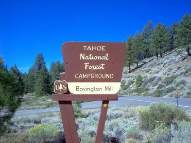
California State Tourism

Overview

Boyington Mill Campground is located along the Little Truckee River, just 20 minutes from Truckee. Visitors enjoy the area for its fishing, abundant hiking opportunities and off-road trails. Stampede and Boca reservoirs are nearby for boating and swimming. This facility is operated and maintained by the Tahoe National Forest.

Recreation

Fly-fishing for rainbow and brown trout in the Little Truckee River is a popular activity enjoyed by visitors to the campground. The surrounding area offers hiking, mountain biking and off-road vehicle trails.
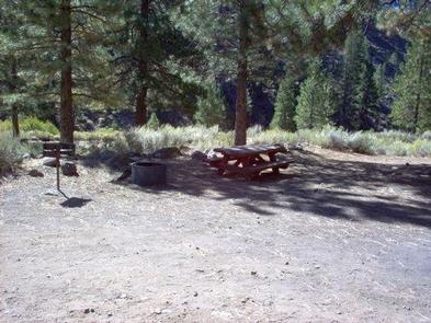
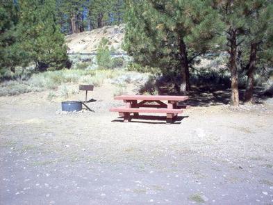
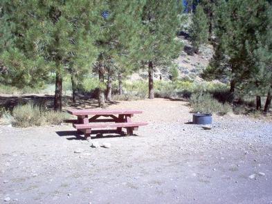
Facilities

The campground offers single-family campsites, each equipped with a picnic table and campfire ring with grill. Vault toilets are provided, but there is no drinking water available at the site.

Natural Features

The campground is situated on the banks of the Little Truckee River, which is known as one of Northern California’s best catch-and-release fly-fishing streams. It is situated among sparse Jeffrey pine and fir trees and shade within the campground is limited.

Nearby Attractions

Boca Reservoir is a couple miles south of the campground. Stampede Reservoir is less than six miles north. Boating, water skiing, swimming and fishing are popular activities on both scenic lakes. Lake Tahoe is located about 35 minutes from the campground and offers excellent boating, kayaking, fishing, hiking and scenic driving opportunities, as well as popular dining, shopping and lodging options. Truckee, 20 minutes away, offers all the amenities of a year round recreational mountain town including interstate highway connectivity, top notch restaurants, resorts and hotels, grocery stores, gas stations, shopping, and historic sites. Other recreational opportunities include Historic Boca Townsite Interpretive Trail, Donner Camp Interpretive Trail, Overland Emigrant Commemorative Trial, Stampede Reservoir Recreation Area, Prosser Pits OHV area, and numerous hiking, mountain biking, and OHV trails.

Reservation

More from CampingHiking.net:

OAK GROVE, Arkansas Campground Images, Info & Reservations

Directions From DeQueen, AR, take Highway 71 north for 3 miles. Turn west onto DeQueen Lake Road and continue for 5.3 miles, following signs into the campground. Phone 870-584-4161 Activities BOATING, CAMPING, FISHING, HUNTING, DAY USE AREA, SWIMMING SITE Keywords OAG2,DEQUEEN LAKE,DEQUEEN LAKE Related Link(s) Rec Area Info & Images

LAKE ALPINE – LODGEPOLE GROUP, California Campground Images, Info & Reservations

Directions From Angel Camp, drive 50 miles east on Highway 4. Phone 209-753-6350 Activities BOATING, CLIMBING, CAMPING, INTERPRETIVE PROGRAMS, FISHING, HIKING, PICNICKING, RECREATIONAL VEHICLES, VISITOR CENTER, WILDERNESS, DAY USE AREA, SWIMMING SITE, SWIMMING, MOTOR BOAT, OFF ROAD VEHICLE TRAILS, PADDLE BOATING, WATER ACTIVITIES, KAYAKING, NON-MOTORIZED BOATING, DISC GOLF, SCENIC DRIVE,

Dub Patton Recreation Area, Mississippi Campground Images, Info & Reservations

Directions From I-55 take the Coldwater, Mississippi, exit and proceed west on Scenic Route 304. Follow the signs to the camping area, which is located just north of the dam. Phone 662-562-6261 Activities BIKING, BOATING, CAMPING, FISHING, HIKING, HUNTING Keywords DUBP,ARKABUTLA LAKE,NORTH ABUTMENT,ARKABUTLA STATE PARK,ARKABUTLA LAKE Related Link(s) Rec Area

LUPINE SHELTER, Montana Campground Images, Info & Reservations

Directions From Wise River, Montana, take the Pioneer Mountains Scenic Byway approximately 25 miles south. Phone 406-832-3178 Activities BIKING, CAMPING, FISHING, HIKING, WINTER SPORTS, WILDLIFE VIEWING Keywords LUPI,LUPINE,SHELTER,BEAVERHEAD-DEERLODGE NF -FS Related Link(s) Rec Area Info & Images Montana State Tourism Montana State Road Conditions Overview Lupine Shelter is a picnicking

HORSETHIEF CABIN, Arizona Campground Images, Info & Reservations

Directions From Phoenix, Arizona: When traveling Northbound on I-17 take the Bumble Bee Exit 248 and continue North on the dirt road, taking Forest Road (FR) 259 to Crown King. From Crown King, take (FR) 259A south for 0.5 mile to the junction of 52. Take FR 52 southeast for

ROBINSON CREEK NORTH, California Campground Images, Info & Reservations

Directions Take U.S. Highway 395 through Bridgeport. Turn south on Twin Lakes Road at the Shell gas station. Travel 9.3 miles on Twin Lakes Road, then turn left into the campground. Phone 760-932-7092 Activities CAMPING, FISHING, HIKING, WILDLIFE VIEWING Keywords ROBI,HUMBOLDT-TOIYABE NF-FS Related Link(s) Rec Area Info & Images California