Directions
From I-90, take exit 85 (Highway 970) and go north approximately 6.5 miles to Teanaway Road. Turn left and drive 13 miles to end of pavement. Veer right onto Forest Service Road (FSR) 9737. Continue 2.2 miles, and then turn right to the Guard Station. From US Highway 2 (Leavenworth or Wenatchee area), follow Highway 97 South from its junction with Highway 2 for 38.5 miles to Teanaway Road. Turn right and drive 13 miles to the end of the pavement. Veer right onto FSR 9737. Continue 2.2 miles and turn right to the Guard Station. From May to mid-November, most passenger vehicles can access the cabin. From mid-December to April, access to cabin is by snowshoe, ski, or snowmobile only. Parking is at Teanaway Sno-Park , 2.2 miles from the cabin. It is an easy ski or snowshoe trip over a groomed snowmobile route. The road and parking area are plowed by road crews. Parking is permitted only on the gravel parking pad. A Washington State Sno-Park Permit is required for parking. Up to 24 inches of snow in a 24 hour period is not uncommon in this area. It is possible upon return to your vehicle you will find it “plowed in.” Please be prepared to dig it out with a shovel. Make sure your vehicle is prepared for winter driving conditions. Carry tire chains, extra food, water and extra clothing.
Phone
(509) 852-1100
Activities
FISHING, HIKING, WINTER SPORTS, WILDLIFE VIEWING, PHOTOGRAPHY, MOUNTAIN BIKING, BIRDING, BACKPACKING
Keywords
TWGS,BEVERLY CABIN,BEVERLY GUARD STATION,TEANAWAY CABIN,OKANOGAN – WENATCHEE NF -FS
Related Link(s)
Washington State Road Conditions
Overview
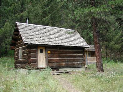
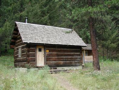
The Teanaway Guard Station is located in the Okanogan-Wenatchee National Forest, north of Cle Elum, Washington. The cabin was originally constructed in 1950 by gold miner Archie Redding, who built the cabin near Mineral Springs, Washington. In 1978, Archie passed away and his cabin came into Forest Service possession. The cabin was then moved to its present location and used as a fire guard station intermittently until becoming available for reservation in 2004. The guard station sits at 3,200 feet elevation in the Teanaway River drainage with the icy North Fork Teanaway River just across the road. It is available for rent early May through mid-November and mid-December through early April. In warmer months, the cabin is accessible by car, but winter access is by ski, snowshoe or snowmobile over a 2.2-mile groomed snowmobile route. Several amenities are provided at the cabin, but guests should be prepared to bring some of their own supplies and gear for a comfortable stay.
Recreation
The nearby Ingalls Way Trail allows hikers to enjoy stunning views of Mt. Stuart and the Enchantments. Fishing is possible in nearby streams. Up to 24 inches of snowfall in a 24 hour period is not uncommon in this area, making it a winter wonderland for cross-country skiing, backcountry skiing and snowboarding and snowshoeing.
Facilities
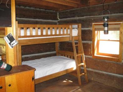
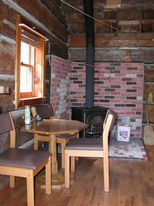
The rustic 12×18-foot log cabin can sleep two people on a set of bunk beds with mattresses. Other amenities include table and chairs, a Coleman propane cook stove and a D battery operated lantern. The stove must be taken outside for use. No stoves or open flames are allowed in the cabin. A wood stove heats the cabin; however, wood is only supplied in the winter and must be split. An axe, splitting maul and wedge are available for guest use. A snow shovel is provided. A picnic table, fire pit and vault toilet are located outdoors. There is no water or electricity available at the site. Guests must bring water for drinking, cooking and washing. Water can be taken from the Teanaway River, but must be treated before drinking. Fuel and D-batteries are not provided for the propane stove or battery operated lantern. Guests must bring their own 16.4-ounce propane canisters and four D batteries, as well as cooking utensils, cookware, backup lighting, sleeping bags, towels, dish soap, matches, toilet paper and garbage bags. All trash and food must be packed out, and guests are expected to clean the cabin before leaving.
Natural Features
The Okanogan-Wenatchee National Forest is defined by its diverse landscapes, boasting high, glaciated alpine peaks, lush valleys of old-growth forest and rugged shrub-steppe country. More than 700 lakes and mountain ponds dot the glacier-carved terrain of nearby Alpine Lake Wilderness. Tree-covered valleys give way to rocky ridges and rugged peaks along the crest of the Cascades. Many peaks and slopes are permanently cloaked in snowfields. From wet forests of Douglas fir, cedar and mountain hemlock, the landscape opens up to expansive meadows and dry forests of ponderosa pine and grasses. Seasonal changes envelop the area as snowmelt gives rise to springtime wildflowers, and autumn colors welcome a landscape blanketed with snow. The area surrounding the cabin is home to abundant wildlife, including deer, squirrels, black bears, mountain lions and migratory birds.
Nearby Attractions
Mountain biking and hiking trails are located within 2 miles of the cabin.


