


Directions
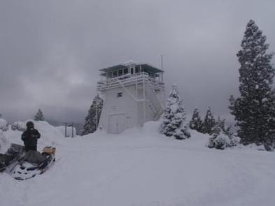
From Sierraville, the lookout is approximately 10 miles north on State Highway 89. Renters will be given a renters packet after check-in with the best access or parking based on current weather conditions. During the winter months, access is by snowshoes, skiis or snowmobiles on a 2 mile trail with a 1000 foot elevation gain.
Phone
(530) 994-3401
Activities
BIKING, CAMPING, HIKING, WINTER SPORTS, WILDLIFE VIEWING
Keywords
CALP,LOOKOUTS,CALPINE LOOKOUT,TAHOE NF – FS,CALPINE LO
Related Link(s)
California State Road Conditions
Overview
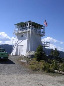
Calpine is a forest fire lookout tower that was constructed in 1934 by the Civilian Conservation Corps, and is one of three remaining examples of the enclosed windmill-style lookout in California. The lookout was actively used every summer until 1975. It is a three-story structure with external stairs. The top room or observation cab is the only rentable space at this time. This is a popular rental facility that is booked almost every night of the year. Calpine sits at an elevation of 5,980 feet in the Sierra Nevada Mountains of the Tahoe National Forest, approximately 40 miles from Truckee, California. During the summer, renters can drive directly to the base of the tower. In winter, the road is often closed due to snow and ice so access is by snowshoes, skis or snowmobile. The lookout has propaned-powered appliances but does not have electricity or water.
Recreation
Hiking and mountain biking trails are within 15 miles of the lookout. The Pacific Crest Trail can be accessed approximately 20 miles away.
Facilities
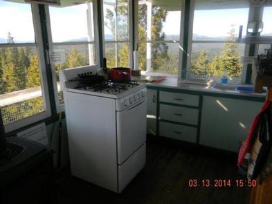
The interior of the cab measures 14′ by 14′ and currently has two single twin beds, a dry sink, a table and chairs, three propane lights, a propane heater, a propane stove/oven and a fire finder. A limited assortment of cooking utensils, pots and pans are provided. The facility has its own propane tank. An accessible vault toilet,a picnic table and fire ring are located outside, at the base of the lookout. Firewood is not provided. When fire restrictions go into effect during the summer, no campfires are permitted. Visitors should plan on bringing their own bedding, groceries, toilet paper and other personal items. Check-in is after 1:00 pm, check-out is by 12:00 pm.
Natural Features
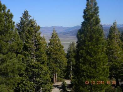
The lookout tower sits on a mountain top with views of the Sierra Valley, Haskell Peak to the west, Nevada to the east and Lassen Peak to the far northwest. The lookout is approximately a half hour of travel time from Sand Pond, Sardine Lakes and the Lakes Basin Area. Wildlife is abundant in the area. On a clear night, renters can gaze on an almost endless galaxy of stars and meteorites.