HAUSER SAND CAMPING, OR Campground Reservation, Info, Images, Map, Directions

HAUSER SAND CAMPING, Oregon Campground Images, Info & Reservations

Directions

From North Bend Oregon, travel North on Highway 101 for 6 miles to Hauser Depot Road. Turn left on Hauser Depot Road and proceed 1/4 mile. Turn left over the railroad tracks onto Sandy Way. Proceed 1/3 mile to the Hauser sand access. To access sand camps #86-#98 turn left onto the sand. To access sand camps #74-85 turn right onto Hauser Beach Sand route.

Phone

541-271-6000

Activities

CAMPING, FISHING, WILDLIFE VIEWING

Keywords

HAOD,DRAG STRIP,HAUSER FLATS,ODNRA,OREGON DUNES,SAND DUNES,SAND CAMPS,HAUSER ODNRA,SIUSLAW NF – FS

Related Link(s)

Rec Area Info & Images

Oregon State Tourism

Oregon State Road Conditions

Overview

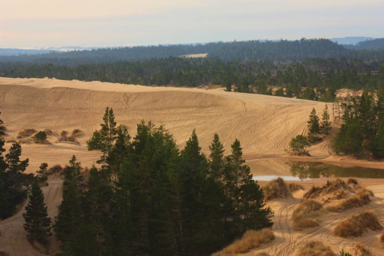
Hauser offers a selection of dispersed campsites in the heart of the largest off-road vehicle area in Siuslaw National Forest. Campsites sit in the middle of the 47-mile stretch of dunelands that make up the Oregon Dunes National Recreation Area. The location is also ideal for its proximity to the Pacific beach and a variety of small lakes.

Many of the campsites at this facility are not able to be reserved in the off season and may be available on a first-come/first-served basis.

Recreation

The sand dune terrain is ideal for thrill seeking off-road riders. A few designated off-road routes include the Hauser Beach Sand Route, the Bark Sand Route and the Coast Guard Sand Route.

Beach goers are just a short ride from the beach, and bird watching is recommended.

Facilities

Standard sites fit five vehicles and up to 20 people. The two group campsites fit 10 vehicles and 40 campers. Note that all sites can only be accessed by 4X4 vehicles. Campsites are available year-round and reservations may fill up quickly in peak summer season. No water is available so campers should bring an ample amount. Campsites are primitive and it’s recommended that all campers bring portable toilets and fire pans. Camp only within designated sites and within 150 feet of the site marker. Seasonal rainfall may affect campsites. Contact Oregon Dunes NRA for seasonal information.

Natural Features

Campsites are in the soft sand of the Oregon Dunes National Recreation Area. The dunefield is known for its wind-sculpted sand dunes towering up to 500 feet above sea level. The Pacific Ocean lies to the west of the campsites and to the north and south, visitors can find many lakes and ponds including Beale Lake.

Nearby Attractions

Head south to Coos Bay, a picturesque inlet where the Coos River flows into the Pacific Ocean. The waterway is about 3 miles wide and 10 miles long, creating a flourishing habitat for sea birds.

Reservation

More from CampingHiking.net:

WOODRING DAY USE AREA SHELTER, Georgia Campground Images, Info & Reservations

Directions From Atlanta: Take Interstate 75 North until Exit 293, turn right onto Georgia Highway 411 North, travel approximately 30 miles; take a right onto Georgia Highway 136 East; proceed across railroad tracks; turn left onto Old Highway 411 North, continue approximately six (6) miles and turn right onto Highway

UMPQUA SAND CAMPING, Oregon Campground Images, Info & Reservations

Directions From Reedsport Oregon, travel 2 miles south on Highway 101 to Winchester Bay. Turn right on Salmon Harbor Drive. Proceed 4 miles to the Oregon Dunes National Recreation Area. Access the sand either at boundary, 2nd Beach Parking Sand Access, or 3rd Beach Parking Sand Access. Phone 541-271-6000 Activities

TAYLOR FERRY, Oklahoma Campground Images, Info & Reservations

Directions Address for GPS: Taylor Ferry South Campground, 33814 E. 746 Rd., Wagoner, OK 74467 From Wagoner, Oklahoma, travel 5 miles east on Highway 51. Turn left on South 330 Road and travel south for approximatly 1/4 mile. Turn left on East 746 Road and travel less than 1 mile

WEST EAGLE CAMPGROUND, California Campground Images, Info & Reservations

Directions From Susanville, California, take Highway 36 for 2 miles west to County Road A-1. Turn north and continue 14 miles to the Eagle Lake Recreation Area, following the signs to the campground. Phone 530-825-3212 Activities BOATING, CAMPING, HIKING, WINTER SPORTS, WATER SPORTS, WILDLIFE VIEWING, SWIMMING SITE Keywords WEEA,LASSEN NF

LONGVIEW, Kansas Campground Images, Info & Reservations

Directions From Perry, Kansas, go 8 miles north on Ferguson road, then 2 miles west on 86th street and follow signs to the campground. Phone 785-597-5144 Activities BIKING, BOATING, CAMPING, FISHING, HIKING Keywords LONV,LAKE PERRY,PERRY RESERVOIR,APPLE VALLEY FARM,PERRY LAKE Related Link(s) Rec Area Info & Images Kansas State Tourism Kansas

KEYSTONE RANGER STATION, Wyoming Campground Images, Info & Reservations

Directions From Laramie, take Highway 130 west, then State Highway 11 to Albany, WY. The cabin is located 8 miles west of Albany, on Forest Service Road 542. In the winter, access to the cabin is 8 miles by snowmobile, skiing or snowshoeing from Albany Snowmobile Parking Lot. Phone 307-745-2300