BLUESTONE LAKE PICNIC SHELTER, WV Campground Reservation, Info, Images, Map, Directions

BLUESTONE LAKE PICNIC SHELTER, West Virginia Campground Images, Info & Reservations

Listen

Directions

From Beckley, West Virginia, take Interstate 64 east to exit 139. Go south on State Route 20 to Hinton and turn right at the first stoplight. Follow Route 20 south and turn left across the New River Bridge. Turn right at the end of the bridge on State Route 3E. Make another right onto Miller Avenue and follow the road to Bluestone Dam.

Phone

304-466-1234

Activities

BIKING, BOATING, CAMPING, FISHING, HUNTING, WATER SPORTS

Keywords

BLUL,BELLPOINT PARK,AREA 1,BLUESTONE DAM,BALL PARK,BELLPOINT BALL PARK,DOWNSTREAM AREA 1,BLUESTONE LAKE

Related Link(s)

Rec Area Info & Images

West Virginia State Tourism

West Virginia State Road Conditions

Overview

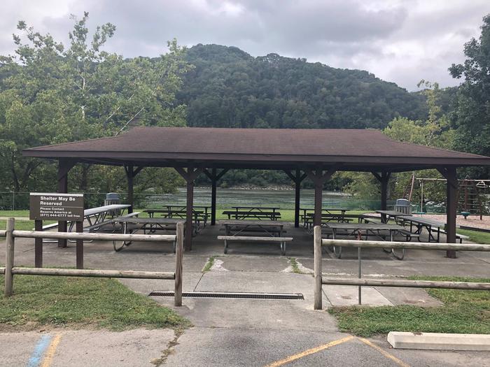
Bluestone Lake Picnic Shelter is a day-use area near the shores of Bluestone Lake in southern West Virginia.

The 2,040 acres of water provide boaters, water skiers and fishermen with plenty of recreational opportunities.

With a capacity of up to 100 guests and dozens of activities and amenities, the day use area is a hot spot for large gatherings and outdoor fun. It is very popular among Little League Baseball groups and fishermen.

Recreation

The New River is the best warm water fishery in West Virginia. Year after year, it produces more citation game fish than any other warm water river in West Virginia. Anglers can cast a line for smallmouth, white and striped bass, bluegill, catfish, crappie and muskellunge.

A short drive to the popular Bluestone Lake Wildlife Management Area won’t disappoint for hunters interested wild turkey, white-tailed deer and various small game.

Facilities

The accessible picnic shelter is equipped with electric and water hookups, as well as restrooms and ample parking. There are 12 picnic tables located around the shelter which seat approximately 75 people.

Basketball, baseball, horseshoe, playing fields and a playground are sure to keep visitors active during their visit.

A boat ramp, dock, pier and marina are a short drive away for the convenience of boaters and anglers.

Natural Features

Visitors won’t want to miss the scenic views of West Virginia’s third largest lake and its surrounding thick forests.

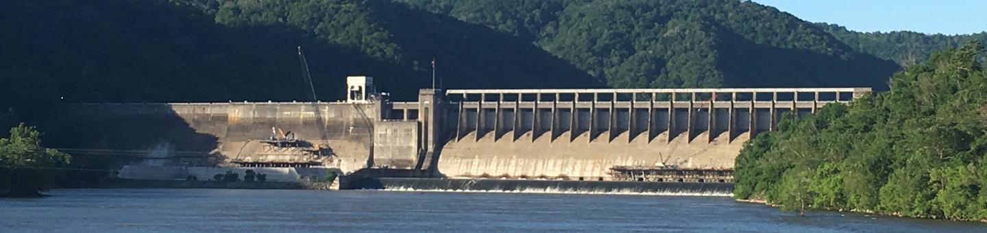
Bluestone Dam spans the New River, forming Bluestone Lake. The New River is the oldest river in North America and partially follows the path of the prehistoric Teays River.

The area is also rich in cultural history, with 103 archaeological sites located on federal property around the lake.

Nearby Attractions

Bluestone State Park has cabin rentals, picnicking and camping facilities, as well as two boat ramps and a marina.

Reservation

More from CampingHiking.net:

LIVE OAK, California Campground Images, Info & Reservations

Listen Directions From Bakersfield, take Highway 178 east to the town of Lake Isabella. From Lake Isabella take Highway 155 north approximately 6 miles to the Live Oak campground. Phone 760-376-1815 Activities CAMPING Keywords LIVO,LAKE ISABELLA,KERN VALLEY,SEQUOIA NF – FS Related Link(s) Rec Area Info & Images California State Road

PORT CHALMERS CABIN, Alaska Campground Images, Info & Reservations

Listen Directions Access to the cabin is by float plane (40 minutes from Cordova, 60 minutes from Seward) or boat (65 miles from Cordova, 70 miles from Whittier, 100 miles from Seward). Best access to the cabin is at high tide. Click here for local tide tables. Winter access may

Henneberry House, Montana Campground Images, Info & Reservations

Listen Directions Access to the cabin is a short distance off I-15 south of Dillon. From Dillon, take the Dalys exit (#51) and turn left under the interstate, then right on the frontage road approximately 1/4 mile to an access gate and parking area on your left. You will need

GREENDALE, Utah Campground Images, Info & Reservations

Listen Directions From Vernal, Utah, take U.S. 191 north for about 40 miles. From Manila, Utah, take Highway 44 for 28 miles. Turn left on U.S. 191 and travel approximately 2 miles north. From Rock Springs, Wyoming, take I-80 west toward Green River about 6 miles to the junction with

CRYSTAL SPRINGS, Arkansas Campground Images, Info & Reservations

Listen Directions From Hot Springs, Arkansas, take US 270 west about 15.4 miles to North Crystal Springs Road. Turn right and follow access road three miles north to the park. Phone 501-991-3390 Activities BOATING, CAMPING, SWIMMING SITE Keywords CRSP,LAKE OUACHITA,CRYSTAL,LAKE OUACHITA Related Link(s) Rec Area Info & Images Arkansas State

LOCK A, Tennessee Campground Images, Info & Reservations

Listen Directions From Ashland City, Tennessee, take US 12 and go eight miles west to Cheap Hill. Turn left on Cheatham Dam Road traveling west four miles. Turn left into the campground. Phone 615-792-3715 Activities CAMPING, HIKING, WATER SPORTS Keywords LOCA,CHEATHAM LAKE,CHEATHAM DAM,CHEATHAM L & D Related Link(s) Rec Area