

Directions
From Baker City: take Highway 30 to Haines, turn west on County Road 1146, and follow the Elkhorn Drive Scenic Byway signs to Anthony Lakes. Turn left at the campground entrance. Anthony Lakes Guard Station is located adjacent to the campground.
Phone
541-894-2332
Activities
BIKING, BOATING, CAMPING, FISHING, HIKING, HUNTING, WILDLIFE VIEWING, WILDERNESS, DAY USE AREA, SWIMMING, MOUNTAIN BIKING, CANOEING, BIRDING, WATER ACCESS, SCENIC DRIVE
Keywords
ANTH,ANTHONY LAKES CABIN,ANTHONY CABIN,WALLOWA-WHITMAN NF – FS
Related Link(s)
Overview
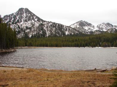
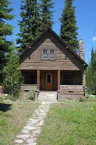
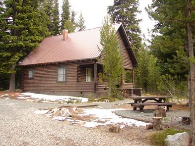
Anthony Lake forms the source of Anthony Creek, named for William ‘Doc’ Anthony, an ambitious homesteader who came to Baker County in 1864. He was a farmer and a doctor, collected tolls on the Dealy Wagon Road for a time, and ran his ranch until he died in 1914 at age 85. Anthony Lake Guard Station is a historic Civilian Conservation Corps log cabin built in the 1930s – one of only a few Forest Service cabins built of logs.
Guests at Anthony Lake Guard Station will find many modern comforts to help make their stay enjoyable. It’s located at a popular recreation area and adjacent to the Anthony Lake Campground, and is easily accessible by car.
Recreation
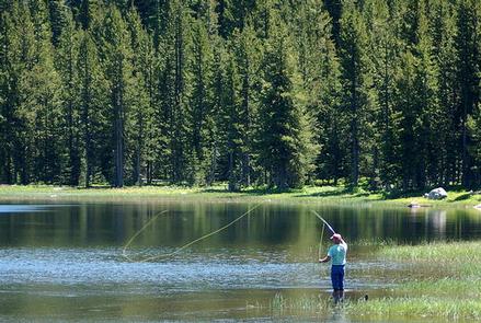
A boat ramp is located on the lake. Activities include boating, canoeing and kayaking. Anglers can fly fish for trout. Trails in the area include the 22.6-mile Elkhorn Crest (foot and equestrian), 1-mile Black Lake (foot and equestrian) and the 1-mile Shoreline (foot).
Facilities
This comfortable, rustic 2-story cabin features a kitchen, a full bathroom with a flush toilet and hot shower, one downstairs bedroom with a full size bed and a futon, two upstairs bedrooms with five twin beds, propane heater and electric lights.
The kitchen is well-equipped with an electric stove and refrigerator, as well as cookware, eating utensils and place settings. Cleaning supplies are provided. A picnic table and campfire ring are just outside the cabin.
Guests are required to bring garbage bags to pack out trash, and they are expected to clean the cabin before leaving. Bedding and towels are not provided, and guests may also wish to bring emergency items, such as flashlights and a first aid kit.
Natural Features
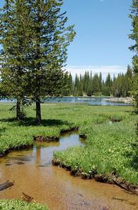
The guard station is situated on the north shore of Anthony Lake, providing a stunning view of the lake and the glacial peaks of the nearby Elkhorn Mountains. The most prominent of these peaks is 8,342-foot Gunsight Mountain. This area is known for conifer forests, wildflower meadows and the resident mountain goats.
The elevation is approximately 7,000 feet, and snow can be expected into July. Anthony Lake is sometimes frozen until mid-June.
Nearby Attractions
The Elkhorn Scenic Byway is a 106-mile drive through the Elkhorn Mountains. Along this drive are ghost towns and an abundance of lakes and rivers. Anthony Lakes Recreation is nearby with mountain bike trails and a seasonal restaurant.