
Directions
From Pomeroy, WA, take 15th Street south (which becomes Peola Road at the city limits) for approximately 15 miles to the forest boundary. The paved road will end here. Continue on Forest Road (FR) 40 for 17 miles to Misery Junction. Take FR 44 east for 3 miles, then FR 43 east for approximately 3 miles. The guard station will be on the left.
The site is accessible by automobile June 1 to November 1. Winter access requires skis, snowshoes or snowmobiles.
For winter use from Pomeroy, travel east on Highway 12 to Clarkston, Washington. From Clarkston, travel south on Highway 129 to Asotin, Washington. Just before entering Asotin, turn right at the bridge onto County Road 105 to Cloverland. Continue past Cloverland to the Sno-Park. Park here, then travel by snowmobile or cross country ski (beginning to intermediate level skiing) southwest on FR 43 to the junction with FR 4304, about 3 miles. Turn right and travel west on FR 43 for a quarter-mile to Wenatchee Guard Station. Pay close attention to the weather forecasts as winter weather can change quickly.
A Washington State Sno-Park permit is required to park at the Sno-Park. Permits may be obtained from any Washington State Park.
Phone
(509)843-1891 OFFICE HOURS MONDAY – FRIDAY 7:30-4:30 CLOSED WEEKENDS AND HOLIDAYS
Activities
HISTORIC & CULTURAL SITE, CAMPING, HIKING, HORSEBACK RIDING, WINTER SPORTS
Keywords
WENA,Wenatchee,Guard Station,Wenatchee Station,Wenatchee Guard,UMATILLA NF – FS
Related Link(s)
Washington State Road Conditions
Overview
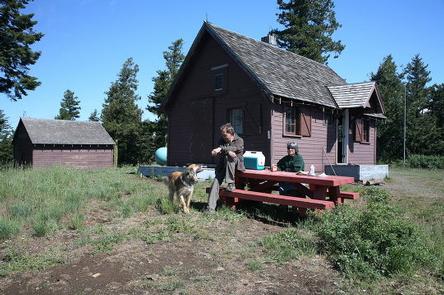
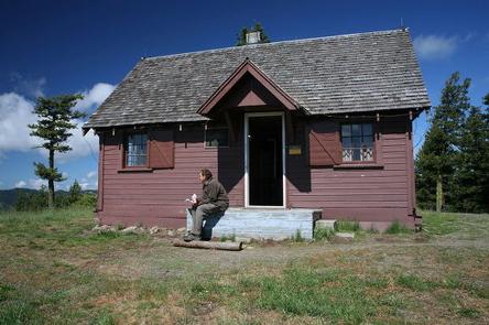
Wenatchee Guard Station, located about 40 miles southeast of Pomeroy, offers a panoramic view of Wenatchee Creek and access to a scenic drive along Wenatchee Creek Canyon. The year-round cabin attracts cross country skiers and snowmobilers in winter and horseback riders and hikers in summer. Dogs and horses are allowed at the cabin.
As early as the 1910s, the site was used as a Forest Guard Camp. In 1927, a log cabin was built and used until it was replaced with the current guard station, completed in 1935 by the Civil Conservation Corps.
Recreation
Horseback riding and hiking trails can be accessed from the cabin. Another way to enjoy views along Wenatchee Creek is by taking a scenic drive. Berry and mushroom picking is possible, and in winter, trails are groomed for snowmobiling and cross country skiing.
Facilities
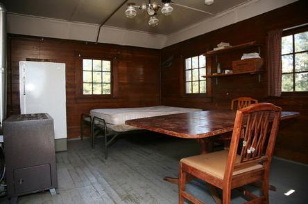
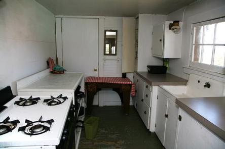
The wood-framed, single story cabin accommodates up to four people. It features a kitchen, bedroom and living room that also serves as a bedroom. Furnishings include four single beds, chairs and a table.
The cabin is equipped with propane for heat, a cook stove, refrigerator/freezer and propane lighting. Most cleaning supplies, limited dishes, pots, pans and utensils are provided. However, it is strongly suggested visitors bring their own. Water is not available on-site. An outhouse is located nearby. Though horses are allowed, there is no corral and no hitching post; horses must be highlined”trailer access to the cabin is difficult.
Things to bring include food, water, sleeping bags or bedding, a flashlight, matches, first aid kit, trash bags, towels and washcloths. Cabin should be cleaned before your departure, cleaning supplies provided.
Natural Features
Wenatchee Guard Station sits at 5290 ft in a grassy clearing on a high plateau dotted with mixed conifers, offering majestic views of the northern tip of the Blue Mountains. In the spring, wildflowers, such as yarrow, Piper’s anemone, Big-leaf sandwort, Showy Aster, Camas pink fairy, daisy and sagebrush sweep color down the slopes into the valleys.
Campers enjoy the view of Grouse Flats and look for herds of Rocky Mountain elk, mule deer and white-tailed deer. They can also listen for the call of geese, ducks, hawks, grouse, wild turkeys, screech owls and wrens.
Nearby Attractions
The cabin is about 35 minutes from any general store. The town of Pomeroy has a county museum, art gallery and antiques.