SQUIRREL MEADOWS CABIN, ID Campground Reservation, Info, Images, Map, Directions

SQUIRREL MEADOWS CABIN, Idaho Campground Images, Info & Reservations

Directions

From Ashton, ID, take Highway 47 a half-mile to Highway 32 and turn right (south). Travel 1 mile to Ashton-Flagg Ranch Road (#261). Turn left (east) and travel 22 miles to Road #032. Turn right (south) and go a half-mile to the cabin.

Phone

208-652-7442

Activities

CAMPING, HORSEBACK RIDING, HUNTING, WILDLIFE VIEWING, HORSE CAMPING, MOUNTAIN BIKING, STAR GAZING, BIRDING

Keywords

SQUI,CARIBOU-TARGHEE NF – FS

Related Link(s)

Rec Area Info & Images

Idaho State Road Conditions

Idaho State Tourism

Overview

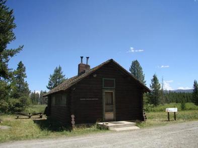
Squirrel Meadows Cabin is located 24 miles east of Ashton, Idaho, just off the Ashton-Flagg Ranch Road. The current cabin was built in 1934, but the site has been used for administrative purposes since 1907. It’s listed on the National Register of Historic Places. Only one other cabin in Wyoming was constructed with the same building plan. The 2-room cabin is made of lodgepole pine and features a wood shingled roof.

Recreation

The cabin provides access to a variety of year-round recreational activities, including horseback riding, cross-country skiing and snowshoeing. Berry picking is available in late summer. Some of the other activities located within a few miles include off-road vehicle and motorcycle riding, snowmobiling, hiking and mountain biking. Game and game bird hunting is a popular pastime in season.

Facilities

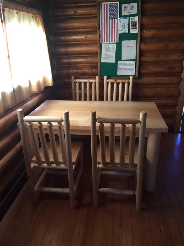
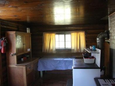
This cabin sleeps six and provides bunkbeds, mattresses, a wood stove for cooking, table and chairs, and firewood. A hand pump, vault toilet, picnic table and horse corrals are located outside. Electricity is not provided. Guests may wish to bring battery or propane-powered lighting. Bedding, matches, and emergency items like a first aid kit are not provided. Trash bags are needed to pack out garbage.

Natural Features

Squirrel Meadows Cabin is situated at 6,500 feet on the Yellowstone Plateau of southwest Wyoming. The cabin sits in a meadow surrounded by pine trees. Guests can enjoy views of the distant mountains. Wildlife in the area includes black bear, wolf, elk, moose, mule deer, and grizzly bear.

Nearby Attractions

Reservation

More from CampingHiking.net:

BONANZA CCC GROUP CAMPGROUND, Idaho Campground Images, Info & Reservations

Directions From Highway 75, turn onto Yankee Fork Road (Forest Road 013) at Sunbeam Dam overlook. Travel approximately seven miles north on Yankee Fork Road and turn left at the Bonanza Guard Station onto Forest Road 074. Continue for approximately half a mile to the campground. Phone 208-879-4100 Activities CAMPING,

NORTH SANDUSKY DAY-USE, Illinois Campground Images, Info & Reservations

Directions From I-57 take take exit 77, and turn west onto Route 154. Continue for 4.5 miles, then turn south on Rend City Road. Continue through the stop sign to the park entrance. Phone 618-724-2493 Activities BIKING, BOATING, HIKING, SWIMMING SITE, DISC GOLF Keywords NSAD,REND LAKE,NORTH SANDUSKY,NORTH SANDUSKY DAY USE,NORTH

WILDWOOD RECREATION SITE, Oregon Campground Images, Info & Reservations

Directions Wildwood Recreation Site is located 39 miles east of Portland on Highway 26 near Welches, Oregon. Phone 503-622-3696 Activities BIKING, HISTORIC & CULTURAL SITE, FISHING, HIKING, PICNICKING, WILDLIFE VIEWING, FISH VIEWING SITE, DAY USE AREA, ENVIRONMENTAL EDUCATION, PHOTOGRAPHY, MOUNTAIN BIKING, BERRY PICKING, BIRDING, WATER ACCESS, BACKPACKING Keywords WIWO,Wildwood Recreation

GIANT GAP, California Campground Images, Info & Reservations

Directions From Interstate 80, take the Auburn/Ravine Road exit. Continue east for 17 miles to Foresthill. Travel through town, about 9 miles, to Forest Road 10/Sugar Pine Road. Turn left and drive 9 miles, crossing a boat ramp and the dam, to the Sugar Pine Campground. Turn right and continue

MAY CREEK CABIN, Montana Campground Images, Info & Reservations

Directions From Wisdom, travel west on Highway 43 for about 16 miles to the May Creek Campground. Guests can park in the plowed parking area near the highway at the entrance to the campground during the winter. During the summer months, follow the campground road to the fence at the

REUNION FLAT, Wyoming Campground Images, Info & Reservations

Directions From Driggs, Idaho, travel 9 miles east. Turn east at the Key Bank on Little Avenue and follow the road to the forest boundary. Turn right on Forest Road 009 and go 3 miles to the campground. Phone 208-270-0150 OR 541-351-1182 Activities BIKING, CAMPING, FISHING, HIKING, WILDLIFE VIEWING Keywords