
Directions
From the north, take State Highway 78 through Absarokee, Montana, to junction with State Highway 419 3 miles south of Absarokee. Turn right (west) and follow State Highway 419 for 21 miles to Nye. Turn right (north), following the directional sign for 1 mile. Turn left (west) at "Y" intersection and travel approximately 5 miles. Turn right (north) at Meyers Creek/Picket Pin Road intersection and follow road for 2 miles, turning left into Meyers Creek Work Center.
From the south, take State Highway 78 from Red Lodge, Montana, to junction with State Highway 419 3 miles south of Absarokee. Turn right (west) and follow State Highway 419 for 21 miles to Nye, MT. Turn right (north), following the directional sign for 1 mile. Turn left (west) at "Y" intersection and travel approximately 5 miles. Turn right (north) at Meyers Creek/Picket Pin Road intersection and follow road for 2 miles. Turn left into Meyers Creek Work Center.
Phone
406-446-2103
Activities
BIKING, CAMPING, FISHING, HIKING, HORSEBACK RIDING, WILDLIFE VIEWING
Keywords
MCAB,Myers Cabin,Mires Cabin,CUSTER NF – FS
Related Link(s)
Overview
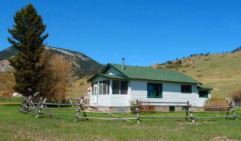
Meyers Creek Cabin is located within the Meyers Creek Work Center in Custer National Forest at an altitude of 5,646 feet. The cabin offers opportunities to enjoy relaxation and recreation in beautiful surroundings. It is reservable from May through November. The cabin is accessible by vehicle. 4-wheel drive is recommended during wet weather.
Recreation
Trails crisscross the area, including the Meyers Creek and Lodgepole Creek Trails. This area offers recreation for hikers, mountain bikers and equestrians. Horse facilities are available at the cabin.
Anglers can fish for rainbow and brown trout in nearby creeks.
Facilities
This cabin sleeps 6 people and comes equipped with 5 single mattresses, an electric refrigerator, cook stove, heat, indoor toilet and shower, cookware, dishes and utensils. A campfire ring is located outside.
There are 2 corrals, a watering tank and hitching rails for horses. Potable water is available, but guests may wish to bring a water filter or provide their own water if they are concerned about quality or taste.
Items such as bedding, towels, washcloths and dish soap are not provided.
Natural Features
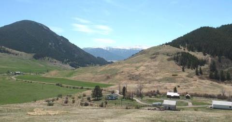
The cabin is situated in the western end of the Beartooth Mountains and surrounded by pastures, which are used for grazing cattle. Roses, irises, rhubarb and lilacs grow around the dwelling. The surrounding slopes are covered in pine, aspen and sagebrush, with wildflowers blooming in the summer. This area supports a large bear population ( bear safety ). Bighorn sheep, elk, deer and a variety of bird species also inhabit the mountainous terrain in the Beartooth Ranger District.
Nearby Attractions
The Stillwater River Trailhead, with access to the Absaroka/Beartooth Wilderness, is 16 miles south of the cabin.