

Directions
From Ennis, take Highway 287 south for 11 miles, to Cameron, Montana. From Cameron, turn east on Bear Creek Loop and continue approximately 6 miles to the cabin.
The last several miles are gravel or dirt roads, which may be muddy or snow-covered and may not always be plowed. Maps (Beaverhead-Deerlodge National Forest-South) may be purchased by calling the Madison Ranger District.
Phone
406-682-4253
Activities
CAMPING, HIKING, HUNTING
Keywords
BECA,BEAR CREEK FOREST SERVICE STAT,BEAR CREEK STATION,BEAR CABIN,BEAR,CREEK CABIN,CREEK,BEAVERHEAD-DEERLODGE NF -FS
Related Link(s)
Overview
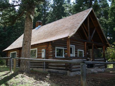
The Bear Creek Cabin allows visitors to experience southwestern Montana’s vast wilderness areas, including wide open fields and a variety of nearby mountain ranges. Situated on the Trail Fork of Bear Creek, the cabin offers a scenic location to enjoy activities such as hunting, skiing, snowshoeing, as well as hiking and horseback riding on nearby trails. A smaller cabin, Bear Creek Bunkhouse, is located about 100 feet to the west and is also on the rental program. The cabin is used as an administrative site in the summer and fall months, but is open to the public between December and April. The site can be accessed by vehicle, however, a portion of the road may be muddy or snow-covered, as it is not always plowed. Visitors are responsible for their own travel arrangements and safety, and must bring several of their own amenities, including water.
Recreation
There are a variety of hiking and horseback riding trails in the area. The trails are popular among visitors for cross country skiing and snowshoeing during the winter months. The nearby wilderness areas do not allow motorized vehicles or bicycles. Camping and fishing in the backcountry are allowed, but the proper permits are required. The Bear Creek Wildlife Management Area immediately to the north of the cabin is closed to all off-trail access, including foot traffic, between Dec. 2 and May 15.
Facilities
You must call the Madison Ranger District at 406-682-4253 Monday – Friday 8:00 am to 4:30 pm for the cabin combination. The office is NOT open on Federal Holidays.
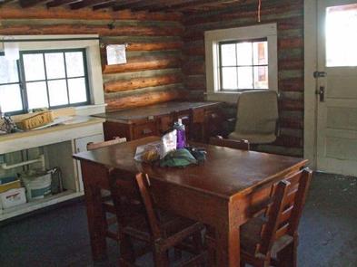
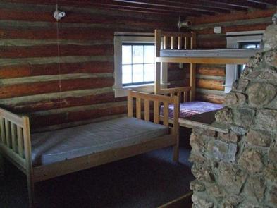
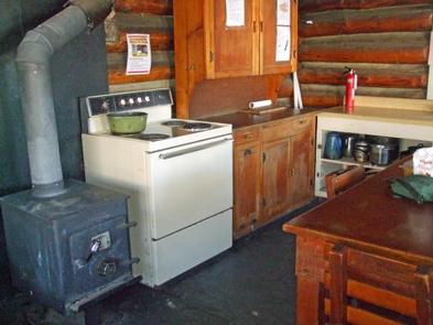
The large, two-room cabin can sleep four people comfortably with one set of bunk beds and two single beds, each with a mattress. The cabin has electricity and is equipped with lights, a refrigerator, a stove and an oven. A table with chairs and basic cooking equipment are also provided.
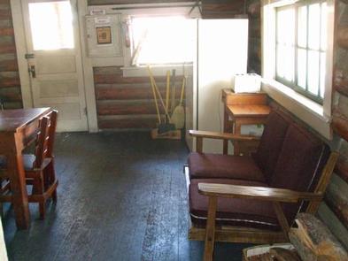
The cabin has a wood stove for heat and comes with firewood, which is usually stacked on the porch and on the side of the cabin. An outhouse with vault toilets is located 40 feet south of the cabin and there are two additional concrete vault toilets adjacent to the campground to the west.
Visitors must bring their own water; the creek is the only source of fresh water and may be difficult to access during the winter. Sleeping bags and extra blankets are not supplied, and users will need to bring their own food, toilet paper and garbage bags, among other necessities.
Garbage and cleaning services are not provided. Renters must clean the facility prior to departure, as well as replenish the supply of split wood and kindling.
Natural Features
The facility is located at the edge of the Lee Metcalf Wilderness, at the foot of the Madison Range. The cabin is situated at an elevation of 6,250 feet, amid open meadows that are surrounded by mature aspens and Douglas fir trees. Bear Creek runs near the cabin and nearby bunkhouse, and the Bear Creek Wildlife Management Area lies immediately to the north. The area is home to a variety of wildlife, including elk, mule deer, black bears and grizzly bears, mountain grouse, and other species (learn more about bear safety).
Nearby Attractions
Bear Creek is approximately 60 miles north of Old Faithful Geyser.