
Directions
From Ashland, Montana: travel east on State Highway 212 for approximately 3 miles. Turn south onto Otter Creek Road hwy 484 and travel 20 miles. Just past the Fort Howes Work Center, turn east onto Taylor Creek Road and travel 12 miles to Sonnette Divide Road. Turn north onto the Sonnette Divide Road for 2 miles then turn east on the Diamond Butte Lookout Road. Travel 1 mile to the lookout.
Phone
CALL FOR COMBINATION PRIOR TO YOUR STAY – M-F 8:00 TO 4:30 CALL 406-784-2344. AFTER HOURS OR WEEKENDS CALL 406-740-1594.
Activities
BIKING, CAMPING, HIKING, HORSEBACK RIDING, HUNTING, WILDLIFE VIEWING
Keywords
DIAB,DIAMOND BUTTE,BUTTE LOOKOUT,DIAMOND LOOKOUT,DIAMOND,BUTTE,LOOKOUT,CUSTER NF – FS
Related Link(s)
Overview
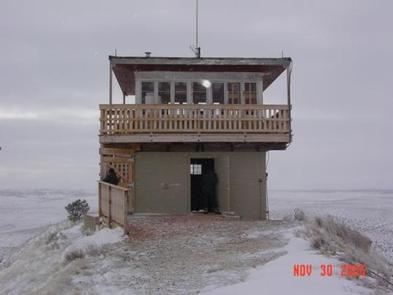
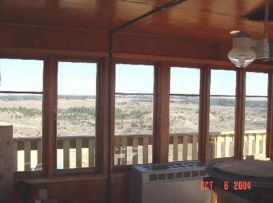
Diamond Butte Lookout is perched atop a 30-foot masonry tower on Diamond Butte at an altitude of 4,245 feet in the Custer National Forest approximately 40 miles from Ashland, Montana. The lookout was moved from its original location of Yeager Butte in 1958 and was an active fire lookout until 2001. Guests can enjoy panoramic views of the surrounding mountains. This vantage point offers the chance to enjoy sunrises, sunsets and star gazing on clear nights. The lookout is accessible by car, but it is a 200-foot walk up a steep hill to the lookout from the parking area. Guests should be prepared to bring most of their own supplies and gear.
Recreation
You can enjoy hiking, horseback riding and mountain biking near the lookout. Opportunities are available to enjoy off-road vehicle riding and hunting.
Facilities
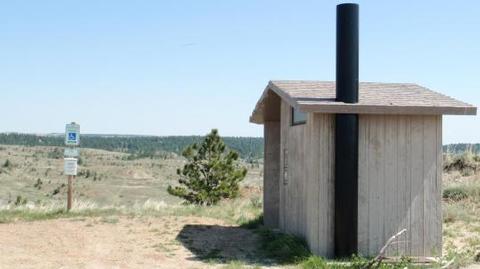
The lookout can accommodate 4 people and is furnished with a table, chairs and1 twin bed with mattress, a double futon with mattress and a cot. Propane appliances include a cook stove with an oven, lights and a heater. A few cooking and eating utensils are provided, along with a broom, mop and bucket. Parking and an outhouse with a pit toilet are located at the gate 200 feet below the lookout. A wagon is stored in the lookout’s basement to help haul gear. Water and electricity are not available. Guests must bring their own water for drinking, cooking and washing. Items such as bedding, lanterns or flashlights, matches, extra toilet paper, first aid supplies, trash bags, dish soap, towels and an ice chest are not available. Guests are expected to pack out their trash and clean the cabin before leaving.
Natural Features
The lookout offers expansive views of the nearby hills and the distant Bighorn Mountains, which are about 100 miles away. Vegetation is sparse, but sagebrush and lupin thrive on the surrounding landscape. Wildlife in the area includes fox, black bear, antelope and a variety of bird species ( bear safety ).