

Directions
From Philipsburg, travel south on Highway 1 for about 7 miles to the junction with Skalkaho Highway/Highway 38. Turn right onto Highway 38 and continue west for about 9 miles and turn left onto Moose Lake Road/Forest Road 5106. Travel another 9 miles to the cabin. Winter weather conditions may require visitors to park on the main road and hike about a quarter-mile to the cabin. Maps may be purchased by calling the Pintler Ranger District.
Phone
406-859-3211
Activities
CAMPING, FISHING, HIKING, HUNTING, WINTER SPORTS, WILDLIFE VIEWING
Keywords
MSLK,MOOSE LAKE GUARD STATION,MOOSE LAKE STATION,BEAVERHEAD-DEERLODGE NF -FS
Related Link(s)
Overview
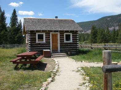
Moose Lake Cabin is located in the Beaverhead-Deerlodge National Forest in southwestern Montana. The historic cabin, which was built in 1917 for use as a Forest Service work cabin, offers visitors access to the Anaconda-Pintler Wilderness Area, which covers almost 250 square miles of mountain ranges.
Many lakes and streams provide ample access to world famous trout fishing and the area also boasts miles of roads and trails for hiking, backpacking, OHV and horseback riding.
The cabin can typically be accessed by vehicle, depending on road and weather conditions. Excessive snowfall may require visitors to walk, ski or snowshoe about a quarter mile from the main road to the cabin. Moose Lake Road is plowed during winter. Guests are responsible for their own travel arrangements and safety, and must bring most of their own amenities.
OHV riders MUST stay on roads and trails!
Recreation
Moose Lake Cabin provides access to hunting, fishing, hiking or just relaxing. Participants must have Montana licenses to hunt or fish, and must only hunt in designated areas. Fishing for brook and cutthroat trout is excellent in the area, which is widely known for its trout-filled mountain streams. The Middle Fork of Rock Creek as well as Copper Creek and other smaller creeks are close by.
Visitors also enjoy snowmobiling, cross country skiing and snowshoeing in the area during the winter. Various weather conditions can increase avalanche danger in the area; visitors are encouraged to carry proper backcountry equipment, including a beacon, shovel and probe while recreating.
Hiking and horseback riding trails lead into the Anaconda-Pintler Wilderness. There are three trailheads in the area, none more than a six mile drive from the cabin. Horses are not allowed in the wilderness area until July 1st each year. As a reminder, pelletized or certified weed seed free feed and straw is required in all National Forests in Montana; please plan accordingly.
Facilities
This is a small, primitive, one-room cabin and is equipped with two sets of bunk beds with mattress pads that can sleep up to four people. It has a small table and chairs and a few pots for heating water.
There is a wood stove for heat and firewood is provided but cannot be guaranteed. A shared outhouse with a vault toilet is nearby and a small dispersed camping area is a few hundred yards from the cabin. A seasonally available hand pump for drinking water, a picnic table and fire pit are also outside.
Guests will need to bring their own sleeping bags and pillows, as well as matches, food, toilet paper, propane stove and garbage bags. There is limited cell phone service available in the area depending on your provider. Guests are asked to replenish the supply of split wood and kindling, pack out all trash and food, and clean the cabin prior to leaving.
There is a fenced pasture for horses next to the cabin but you must check the fence for damage before using it. Do not corral your horses on the cabin grounds.
This cabin is also about a mile from Copper Creek Campground.
Natural Features
The cabin is located on the Middle Fork of Rock Creek (Moose Lake Road, FR 5106) near the Anaconda-Pintler Wilderness. It sits at the edge of an open meadow, surrounded by evergreens and towering peaks. And the Middle Fork of Rock Creek flows about 100 yards behind the cabin. There is easy access to the creek.
The area is known for its high, rugged and beautiful mountain scenery, as well as the variety of wildlife that makes its home there, including elk, moose, deer, mountain lions and bears (learn more about bear safety).
Nearby Attractions
The Skalkaho Highway (Highway 38) leads into the Sapphire Mountains along a primitive and once widely used Native American trail. The scenic drive, which is closed during winter, was built to provide access between mining areas and agricultural communities in the Bitterroot Valley. About 30 miles from the cabin, the road leads to Skalkaho Falls in the neighboring Bitterroot National Forest.
Charges & Cancellations
Reservations are nonrefundable unless extenuating circumstances warrant otherwise. Determination will be made on a case by case basis.