
Directions
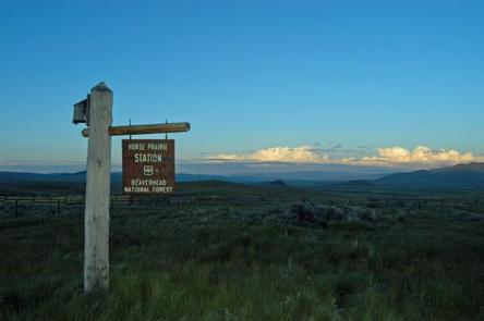
From Dillon, travel south on Interstate 15 for about 20 miles, to Highway 324. Cross the Clark Canyon Reservoir Dam and travel west on Highway 324 for about 21 miles. At Red Butte, continue west on Forest Road 181 (Bloody Dick Road) for about 6 miles to the junction with Forest Road 7340 (Coyote Creek Road). Continue about 2 miles to the cabin. In winter, over-the-snow distance to the cabin will vary from 1 to 6 miles. Maps may be purchased at the Dillon Ranger District 420 Barrett Street, Dillon, MT 59725 – Monday through Friday from 7:30-16:30 mst. Or using a computer – http://www.fs.usda.gov/bdnf (mobile map applications are available).
Phone
406-683-3900
Activities
BIKING, CAMPING, FISHING, HIKING, HUNTING, WINTER SPORTS, WILDLIFE VIEWING
Keywords
HRPR,HORSE PRAIRIE GUARD STATION,BEAVERHEAD-DEERLODGE NF -FS
Related Link(s)
Overview
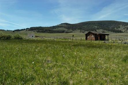
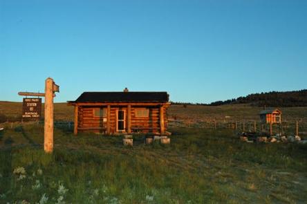
Horse Prairie Cabin is a fairly large, two-room cabin situated on the edge of beautiful Horse Prairie in the southwestern corner of Montana. Forest service work crews used the cabin for lodging in the past.
The cabin is available year-round and provides access to abundant hiking, biking, skiing and snowmobiling trails. It is equipped with a variety of amenities, providing guests with a somewhat comfortable and adventurous experience in the Beaverhead-Deerlodge National Forest.
The cabin is accessible by vehicle, depending on conditions. Excessive snowfall may require skis, snowmobiles or hiking for up to six miles of the route. Guests are responsible for their own travel arrangements and safety, and must bring several of their own amenities.
Recreation
Hikers and mountain bikers can access some great trails in the area. To the west of the cabin, Coyote Creek Road provides access to excellent cross-country skiing. Coyote Creek Road runs approximately seven miles to the top of the Big Hole Divide, climbing about 1,500 feet. The prairie and surrounding area is also open to unlimited snowmobile access during the winter (learn about avalanche danger).
Fishing is available in nearby creeks, and anglers might see rainbow and brook trout, as well as mountain whitefish. The waterways drain into the Big Hole River, a blue-ribbon trout stream at the southern end of the forest.
Facilities
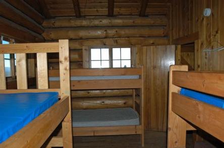
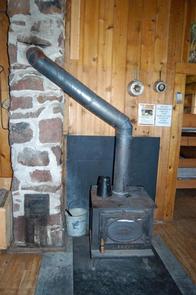
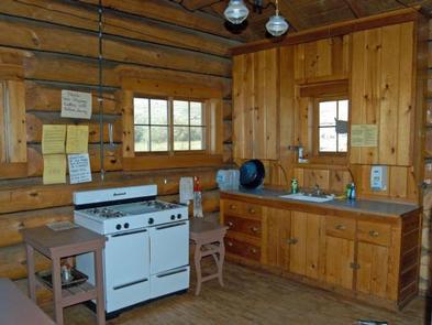
The two-room log cabin comes equipped with bunk beds and mattresses to sleep up to four people, as well as a table and chairs. It has a wood burning stove for heat. Propane appliances include a stove, oven and overhead lighting. The kitchen area of the cabin is stocked with basic cookware, utensils, dishes and tableware. There is ample cupboard and counter space for food preparation and storage. Drinking water is provided June through September. Cleaning equipment, including a mop, broom and dustpan, is provided, as well as a bucket, shovel and an axe. An outhouse with a vault toilet is located nearby. Guests need to bring their own bedding, including blankets and pillows, as well as matches, food, flashlights, toilet paper, garbage bags and other necessities. Firewood may be available, but the supply cannot be guaranteed. Guests are asked to replenish the cut wood supply, pack out all trash and food, and clean the cabin prior to leaving. Limited cell phone coverage is available (depending on carrier).
Natural Features
The cabin is located on a hillside in a sunny, open prairie on the southern edge of the Beaverhead Mountains. The range straddles the Continental Divide in Montana and Idaho. The view from the cabin overlooks the grassy meadows of Horse Prairie.
There is abundant wildlife in the area, including elk, moose, mountain goat, bighorn sheep, lynx, marten, deer and black bears (learn more about bear safety).