


Directions
From Redding California, or Mt. Shasta, take Interstate 5 towards Castle Crags State Park. Exit the Interstate at the Soda Creek exit 726. From here, the lookout is approximately 7.5 miles over mostly dirt road. Head east towards the Sacramento River. Cross the bridge over the river and veer right until you come to a road intersection. Turn right on Riverside and follow a curvy and narrow paved road to the intersection of the Girard Ridge Road (Forest Service Road Number 38N23). Turn left, heading up hill. The road will change from pavement to dirt at the 1.9 mile mark from I-5. You will pass some microwave towers. At the top of the hill at approx 6.5 miles from the interstate look for a road intersection, this is Forest Service Road Number 39N13. It will be your first left. Turn here and travel approximately .6 mile to an unnumbered road again on your left. A sign says Girard Ridge Lookout with an arrow. Turn here and you will come to a green Forest Service gate. Open the gate and travel on this road until you reach the lookout (about 1/2 mile).
Phone
530-964-2184
Activities
HISTORIC & CULTURAL SITE, CAMPING, FISHING, HIKING, HUNTING, WILDLIFE VIEWING
Keywords
GIRR,GIRARD,GIRARD LOOKOUT,RIDGE,LOOKOUT,SHASTA-TRINITY -FS
Related Link(s)
California State Road Conditions
Overview
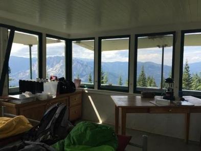
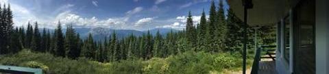
Girard Ridge Lookout was constructed in 1931 and used by the Forest Service on a regular basis until 1981. It is one of the few remaining historic lookouts on the Shasta-Trinity National Forest. The structure at Girard Ridge is reportedly the oldest lookout of its particular design remaining in California. It was restored to its original character in 1997. The lookout offers primitive accommodations, but visitors are rewarded with panoramic views of the mountains during the day and bright, starry skies at night. Staying at Girard Ridge Lookout is an unforgettable experience.
Recreation
While the main recreation at Girard Ridge Lookout is enjoying the scenery, there are opportunities to hike, hunt, and fish. Hikers can walk north on the Forest Service road for 3 miles from the lookout to where it meets the Pacific Crest Trail.
Facilities
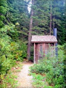
Girard Ridge Lookout stands 13 feet off the ground and is accessed via a flight of stairs. It has a standard 14×14 foot cabin with a gable roof and exterior catwalk. There is a separate building with a vault toilet that is accessed by going down the stairs and walking about 30 feet. The cabin offers two twin beds with mattresses. Cabinets are available for storage and there is a table for eating. Visitors have access to cleaning supplies, including a mop, broom, and cleansers. The lookout has no cooking facilities, no water and no electricity. Visitors are required to bring water. A heat source is needed in cooler temperatures. There are no dishes, utensils, cookware, linens or bedding at the lookout. Visitors must bring garbage bags to pack out trash. The use of portable stoves using gas, jellied petroleum or pressurized liquid fuel is allowed with a valid California campfire permit, but no wood or charcoal fires are permitted ( Click here for more information about Girard Ridge Lookout).
Natural Features
The lookout is located above the Sacramento River Canyon at a height of 4,809 feet. Spectacular views of Mount Shasta are seen to the north, the gray spires of the Castle Crags frame almost the entire view to the west and the distant silhouette of Lassen Peak can be seen to the southeast. Girard Ridge Lookout is surrounded by northern California mixed conifer forest. Bears and other animals live in the surrounding forest (click here for information on bear safety).
Nearby Attractions
Castle Crags State Park is nearby, offering hiking trails, including access to the Castle Crags Wilderness in the Shasta-Trinity National Forest, and the chance to fish and swim in the Sacramento River.
Charges & Cancellations
A $10.00 service fee will apply if you change or cancel your reservation. Late cancellations are subject to additional fees. For full details see NRRS Reservation Policy