
Directions
Located 25 miles southwest of Helena, Montana in the Little Blackfoot drainage, the cabin can be reached via US Highway 12, turning left (south) onto Little Blackfoot River Road just east of Elliston. From this intersection, it is approximately 16 miles to the cabin. The cabin is located on the north side of the road, directly across from the entrance to Kading Campground.
During the winter months, Little Blackfoot River Road is only plowed on a regular basis as far as Hat Creek. Normally, the county plows the road to this point and makes a turn-around for parking. Approximately 7 more miles of unplowed road remain to reach the cabin. This section of road is closed to vehicles but open to those who like to ski, snowmobile or use dog sleds.
Phone
406-449-5201
Activities
BIKING, CAMPING, FISHING, HIKING, HORSEBACK RIDING, HUNTING, WINTER SPORTS, WILDLIFE VIEWING
Keywords
KADI,KADING GUARD STATION,CADING CABIN,CADING GUARD STATION,LITTLE BLACKFOOT,LITTLE BLACKFOOT RIVER CABIN,LITTLE BLACFOOT RIVER,HELENA NF – FS
Related Link(s)
Overview
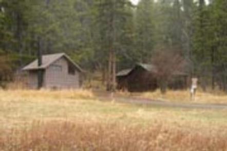
Kading Cabin is located 16 miles south of Elliston, Montana in Helena National Forest. This site has served the Forest Service since the early 1900s when the agency was forming. It was selected for its central location, trail and wagon road accessibility, and telephone line service at the time, ensuring that it would be valuable for both administrative and protective work.
The present cabin was built in the 1930s by the Civilian Conservation Corps. Renovations and repairs were made to the facility in the 1960s and again in the early 1990s. Today, the cabin is a rustic retreat for guests seeking relaxation and recreation in central Montana.
The cabin is typically accessible by car; however, heavy amounts of snow in winter can close the road to vehicles. Access to the cabin is via a 7-mile stretch of road passable by snowmobile, snowshoe, skis or dog sled. Guests must be prepared to pack in several of their own supplies.
Recreation
Plenty of hiking, fishing and wildlife viewing opportunities exist along the numerous trails and roads that can be accessed within a short distance from the cabin.
Fly fishing on the Little Blackfoot River is excellent. Brown trout are found in good numbers and large sizes below Elliston. Brook and cutthroat trout are found above Elliston. Whitefish can be found throughout the length of the river.
In winter, guests will enjoy snowshoeing, skiing and snowmobiling on trails throughout the area.
Facilities
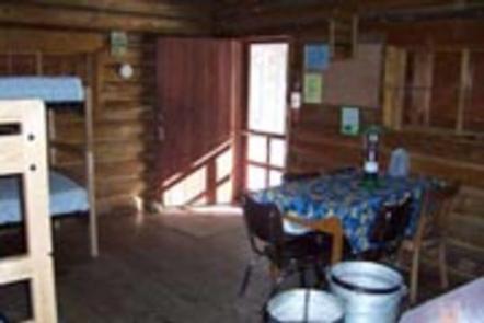
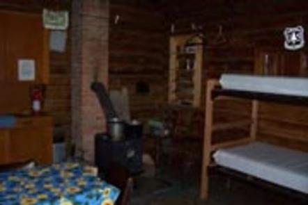
The cabin is furnished with 2 sets of bunk beds with mattresses that can accommodate up to 4 people. A wood stove is provided for heat. Other amenities include propane lanterns, a table and chairs, cleaning supplies, a propane cooking stove, dishes, utensils and some cookware.
An outhouse with vault toilet is nearby. An axe and snow shovel are provided. Firewood may be available, but it is not guaranteed. A water spigot is located outside the cabin and operates most of the winter.
The cabin is not wired for electricity, and water is not always available in winter. Fuel is not provided for the propane stove or lanterns, so guests should bring a couple of small propane cylinders, as well as backup lighting.
Items to bring include sleeping bags, linens, towels, dish soap, matches, first aid kit, toilet paper and garbage bags. Guests are expected to pack out all trash and food and clean the cabin before leaving.
No firewood provided from June 1st – August 31
Natural Features
Hemmed in by old-growth, conifer forest, Kading Cabin sits at the edge of a grassy clearing. The Little Blackfoot River flows near the cabin, a tributary to the Upper Clark Fork watershed. It drains an area of 265,300 acres from the Boulder Mountains north of Butte and west of Helena.
The area around the cabin offers a variety of landscapes, from river banks to subalpine terrain. Valley bottoms, dense forests, meadows and barren ridges are mixed with streams, rivers, and lakes.
Wildlife in the area abounds. Elk, deer, squirrels and a variety of birds are commonly seen. The more elusive badger, wolverine, mountain lion and lynx find habitat in nearby areas as well.
Nearby Attractions
Plenty of historic mines are scattered throughout the area, including Charter Oak Mine and the Mill and the Monarch Mine.