

Directions
The cabin is located 8.5 miles east of Lincoln, Montana and can be reached via Hogum Creek Road, which is approximately 6 miles east of Lincoln on Highway 200. Follow Hogum Creek Road to the junction of Black Diamond Road and Lower Hogum Creek Road. Lower Hogum Creek Road will take you to the cabin driveway. The driveway is on the left and is signed with a wooden sign and blue ski blazers. During the winter months, snow plowing occurs infrequently on the Lower Hogum Creek Road. Be prepared to hike, ski, or snowmobile up to one mile to reach Cummings Cabin in the winter. A parking area is plowed in at the jct with Black Diamond road, visitors traveling beyond this point to the cabin in the winter should be prepared for snow drifts and adverse conditions. There is usually a large sled stored at the cabin in the winter months to assisst with moving renter’s supplies. Please respect the private lands that border the west side of the cabin site and do not block the Lower Hogum Creek Road.
Phone
406-362-7000
Activities
BIKING, HISTORIC & CULTURAL SITE, CAMPING, FISHING, HIKING, HUNTING, WINTER SPORTS, SNOWMOBILE, MOUNTAIN BIKING, CROSS COUNTRY SKIING, SKIING
Keywords
CUMM,HOGUM,CUMMINGS,HELENA NF – FS
Related Link(s)
Overview
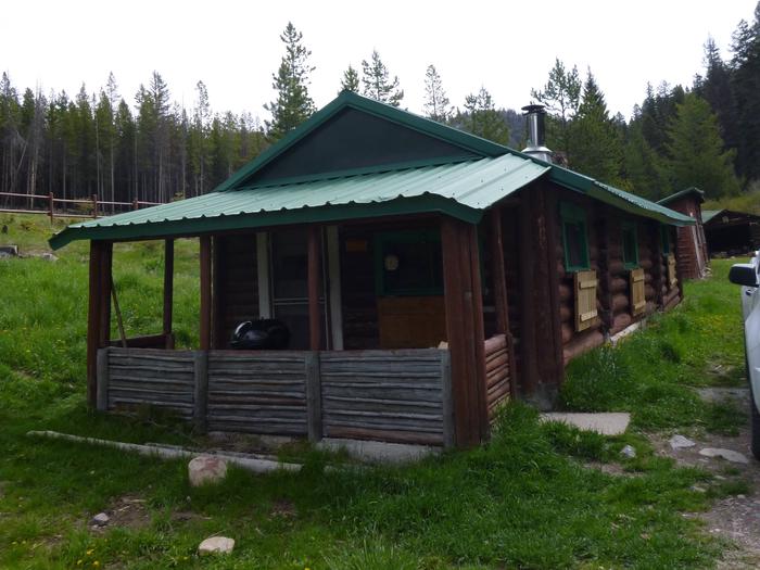
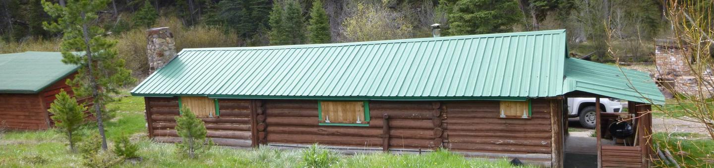
Located 8.5 miles east of Lincoln, Montana, Cummings Cabin is a historic structure, representative of the old mining cabins that dotted the countryside in the greater Lincoln area around 1910. The cabin has been determined eligible for inclusion to the National Register of Historic Places. Today, the cabin is a rustic getaway for guests seeking relaxation and recreation in the Helena-Lewis and Clark National Forest. The cabin has a hand pump for water, propane range, propane lights, a wood stove, silverware, dishes, cleaning supplies, outdoor fire ring, 2 full size beds and one twin bed. In the snow free months guests can drive directly to the cabin, but in the winter be prepared to snow shoe or ski up to a mile to get to the cabin.
Recreation
Guests can access numerous trails within a half hour drive of the cabin. The Lincoln valley is bounded by the Continental Divide Trail to the east and visitors can access this trail in numerous places from Cummings Cabin. Guests can also explore the Scapegoat Wilderness and the Lewis and Clark Historic trail while visiting the area. OHV enthusiasts can ride directly from the cabin to access the Hogum Creek ATV trail which connects up to Crater Mtn. road and the Stemple Pass area. Wildlife, flowers, and spectacular views can be seen from many locations in the valley. The nearby Blackfoot River ranks as one of the most scenic rivers in this part of Montana and Cummings Cabin is located near its headwaters. Excellent fly fishing can be found within a short distance of the cabin. The cabin also offers winter recreation opportunities with cross-country skiing opportunities out the back door and nearby access to over 200 miles of groomed snowmobile trails.
Facilities
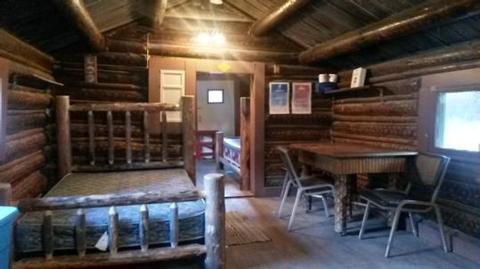
The cabin is furnished with two double beds and one twin bed, all with mattresses, and is able to accommodate up to five people. The kitchen is equipped with a propane range and oven, a variety of pots and pans, plates, bowls, cups, cutlery, a sink that drains into five-gallon buckets, and a table with chairs.
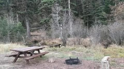
A wood stove and a fireplace are available for use. An axe is available for splitting wood and firewood is usually available on the front porch as well as in the old garage; however, it is not guaranteed. Call the District to confirm the availability of wood at the cabin. A vault toilet is on-site near the cabin.
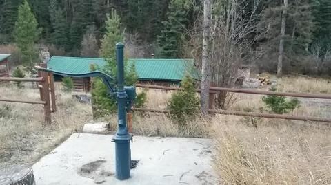
The cabin does not have electricity or indoor plumbing. There are eight propane lights for renters use with spare mantles usually stocked in the cabinet. Water is available year-round from a hand pump, but may be difficult to draw during extreme cold temperatures. If water is collected from the nearby stream, it should be treated prior to use.
Guests are advised to bring personal items, sleeping bags or blankets, linens, towels, dish soap, matches, first aid kit and garbage bags. All garbage must be packed out, and guests are expected to clean the cabin before leaving. Brooms, mops and basic cleaning supplies are available for renters use.
Propane is provided for visitors. There is a shut off valve on the outer wall of the cabin on the North side. Always turn propane off to the cabin when not in use to avoid gas leaks. Always keep individual propane control knobs to the lights and the stove in the off position when not in use.
Natural Features
The cabin is tucked into a grassy clearing with old-growth conifer forest to one side.
The area around the cabin offers a variety of landscapes, from river banks to subalpine terrain. Valley bottoms, dense forests, meadows and barren ridges are mixed with streams, rivers, and lakes.
Wildlife in the area abounds, including the more common elk, mule and white-tailed deer, squirrel, black bear, and a variety of birds. The more elusive grizzly bear, badger, wolverine, mountain lion, and lynx find habitat here as well.
Nearby Attractions
The town of LIncoln is about 8.5 miles to the West. Guests can visit one of the many local restautrants or bars, tour the Blackfoot Sculpture Park, attend local festivals, and participate in many of organized events that take place in town throughout the year.