

Directions
From Ruidoso on Mechem Drive, take Cedar Creek Road west .5 miles. Cedar Creek is the first recreational area located on the right (north).
Phone
575-257-4095
Activities
BIKING, CAMPING, HIKING, WILDLIFE VIEWING
Keywords
CEDC,SAM TOBIAS GROUP CAMPGROUND,CEDAR CREEK SAM TOBIAS,LINCOLN NF – FS
Related Link(s)
New Mexico State Road Conditions
Overview
Located on the outskirts of Ruidoso, Cedar Creek provides a wonderful space for groups visiting for the day or staying overnight. With a picnic shelter and three group campsites, the recreation area is ideal for an outing in Lincoln National Forest. A popular pastime is is hiking and mountain biking along the scenic multi-use trails adjacent to the Sam Tobias Memorial Group Campground. There are opporunities to see a number of different wildlife, including Mule deer and Elk in the area.
Recreation
Hiking and biking are among the most popular activities here, with options like the T90 fitness Trail which extends 1.3 miles and includes exercise stations. Bilking trails T120 A-D and T121 A& B are also nearby. Also we have an expert-only downhill mountain bike trail, located near the water tower to the east of the Campgrounds. The trail ends at the picnic area. Dogs must be kept on leash at all times while hiking. Dogs are not allowed on the Fitness trail.
Facilities
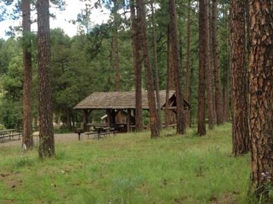
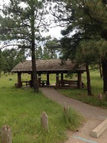
The group picnic shelter offers drinking water and accessible vault toilets. Non-sheltered picnic tables are open to the general public.
The group campgrounds range from 60 to 100 person capacities and the group picnic shelter fits up to 40 people. Each site comes with accessible picnic shelters, campfire rings, drinking water vault toilets and grills.
Picnic Pavilion is for day use only. If you would like to camp overnight please book one of the group campgrounds.
Natural Features
Cedar Creek is perched along its namesake, Cedar Creek at a 7,000 foot elevation. Lincoln National Forest, located in south-central New Mexico, is most notable as the birthplace of the original Smokey Bear.
Nearby Attractions
Ruidoso is a delightful town with quaint shops, restaurants and art galleries. If picnickers wish to camp overnight, they can head to Sam Tobias Memorial Group Campground.