
Directions
Entry to the lookout is by combination lock. Please call the Sisters Ranger District at (541) 549-7700 one week in advance to get the gate combination. From Sisters, travel 5.5 miles west on U.S. Highway 20 to Forest Road 11 at Indian Ford Campground. Turn right on Forest Road 11 and travel approximately 10 miles to the end of pavement at the junction with Forest Road 1150. Take the left fork of Forest Road 1150, to the junction with Forest Road 1154. Turn left on Forest Road 1154 and continue to Forest Road 1140. Turn left on Forest Road 1140 and continue a short distance to spur road 600. Take a very sharp right on spur road 600, and travel approximately 0.5 miles on the spur road to the parking area for Green Ridge Lookout. Early and late season travel may require high clearance four-wheel drive vehicles. If snow blocks access to the facility during the early season, opening may be delayed. In the event of a delayed opening, reservations will be canceled and money refunded. Please contact the Ranger District at (541) 549-7700 prior to arriving at the cabin to check on any restrictions or conditions, such as fire or road closures, weather or storms that may affect the quality of your visit.
Phone
(541) 549-7700
Activities
CAMPING, FISHING, HIKING, MOUNTAIN BIKING
Keywords
GREO,GREEN RIDGE LOOOKOUT,GREEN RIDGE,GREEN,RIDGE,LOOKOUT,RIDGE LOOKOUT,DESCHUTES NF – FS
Related Link(s)
Overview
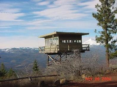
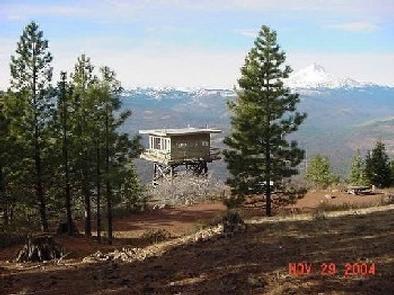
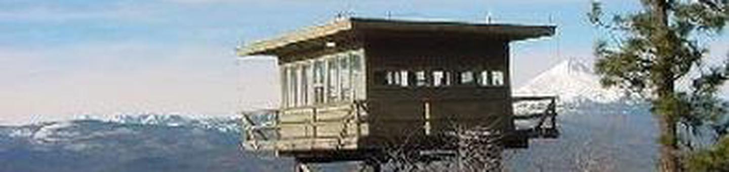
Green Ridge Lookout is perched on a ridge more than 2,000 feet above the Metolius River. It offers guests a unique lodging experience in Deschutes National Forest. The lookout, a 20-foot tall fire lookout with unmatched views of Mt. Jefferson and the Metolius River basin, was built in the 1960s.
Green Ridge Lookout is available for rent early May – June and mid September – mid November. During the summer months, the lookout is staffed with Forest Service volunteers who help with forest fire detection.
Recreation
Fishing and hiking top the list of recreational activities in the area. For anglers, the Metolius River offers a stunning setting for fly-fishing. Its clear, cold waters support rainbow trout, whitefish, bull trout and kokanee salmon.
For day hikers and backpackers, the area offers a wide variety of scenic terrain, ranging from riverside trails to routes through subalpine forests. Several pleasant day hikes are found along the Metolius River and to the top of Black Butte.
Lake Billy Chinook, approximately ten miles away, offers boating and fishing opportunities.
Facilities
The R6 style cab sits on a two-story tower hugging the side of Green Ridge. From the parking area, there is a short boardwalk to the lower 20×20-ft. wooden deck. A one story flight of steps leads to the catwalk of the upper deck surrounding the cabin. The one-room cabin is furnished with a futon, a table and two chairs. It is also equipped with a propane refrigerator, an overhead light, a propane wall heater, a three-burner propane stove and oven and basic cooking utensils. Guests must bring several of their own amenities, including food, water, sleeping bags, sleeping pads, towels, dish soap, matches, toilet paper and garbage bags. There is no water available at the site. Guests must bring water for drinking, cooking and washing. Although lighting is available, bringing an additional light source is recommended.
Natural Features
Guests to Green Ridge Lookout are treated to views of snow-capped mountain peaks and dense forests of Douglas-fir, cedar and Ponderosa pine that stretch out to the horizon. Mount Jefferson, the most prominent peak in view, is a stratovolcano that reaches an elevation of 10,497 feet, the second highest mountain in Oregon. The scenic Metolius River flows through the basin beneath the tower lookout. The headwaters of the river are at Metolius Springs at the base of nearby Black Butte, a 6,436 ft. cinder cone. The clear, cold river flows north from the springs through diverse coniferous forest and a landscape of volcanic activity.