


Directions
From Albuquerque, drive east on I-40 to Exit 175. Proceed north on State Highway N-14 about 7 miles to State Road 536. Turn left or west, onto 536 and drive about 9 miles up to the picnic site and look for signage on your left. It is easy to miss, as the gate is set back from the road. A land mark to help you is, Capulin Picnic Site. Nine Mile Picnic Site is approximately a mile past Capulin, on the left.
Phone
505-281-3304
Activities
BIKING, CLIMBING, HIKING, WILDLIFE VIEWING
Keywords
NINE,9 MILE,CIBOLA NF – FS
Related Link(s)
New Mexico State Road Conditions
Overview
**Nine Mile Picnic Site is currently closed for improvements**
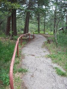
If you are looking for a quiet, relaxing, cool spot with a slight breeze, Nine Mile Picnic Site could be just what the doctor ordered. Nine Mile Picnic Site is located just off State Road 536 near the nine mile marker on the left side as you wind your way up State Highway 536. It is surrounded by aspen, spruce and fir trees. In the fall, the aspens cast a golden hue over the entire area, which creates an alluring draw to the picnic area. Nine Mile has old paved roadways within the picnic site that are just right for a short walk through the forested area.
Please remember to take extra care to “Leave no trace” when you visit your public lands. There is no overnight camping at Nine Mile.
Recreation
Picnicking and relaxing are the main activities in Nine Mile Picnic Site.
Facilities
This facility can handle up to 50 people. There is no shelter, but there is plenty of shade provided by the aspen, spruce and fir trees that grow within Nine Mile. It is peaceful.
Water and electricity, firewood /charcoal are not available at the site. Accessible vault toilets and bear proof trash receptacles are provided. Bears frequent the area; use appropriate containers for food and garbage.
PARKING: Each reservation comes with ten day use parking passes which should be picked up before hand, at the Sandia Ranger Station, Wednesday through Friday between 8:00 a.m. and 4:30 p.m., (505) 281-3304.
*Additional dispersed picnic sites, which do not require a reservation, are available on a first-come, first-served basis. Each site can accommodate a small family group and have no covering. Tables and grills provided.
Natural Features
The area is heavily wooded, with a mixture of level and hilly ground.
Nearby Attractions
There are privately owned businesses and restaurants all along NM State Road 14 and a museum on your way up the 536 Scenic Byway.
If you are interested in taking a short jaunt to the very top of the Sandia Mountains, just take a left turn out of the Nine Mile parking area, onto the Sandia Crest 536 Scenic Byway, and wind your way up. The Byway extends 13.6 miles from the base of the Sandia to the Sandia Crest.
At the Sandia Crest there is parking, a gift store, snack bar and a lookout deck. There you can see panoramic views from any direction you look. Sunsets are spectacular. It was voted Best Place to “Pop the Question” in 2010. It is a popular path for motorcyclists and auto touring, with its winding road to the peak.
The Peak area provides two launch pads for hang gliding, which is a popular sport during summer months.