PEARCH CREEK CAMPGROUND, CA Campground Reservation, Info, Images, Map, Directions

PEARCH CREEK CAMPGROUND, California Campground Images, Info & Reservations

Directions

From Orleans, California, follow State Highway 96 north approximately 1.5 miles to the campground.

Phone

530-627-3291

Activities

BIKING, BOATING, CAMPING, FISHING, HIKING, HUNTING, VISITOR CENTER, WATER SPORTS, WILDLIFE VIEWING, SWIMMING SITE

Keywords

PEAR,SIX RIVERS NF -FS

Related Link(s)

Rec Area Info & Images

California State Road Conditions

California State Tourism

Overview

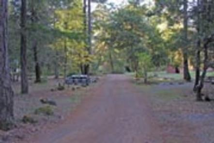
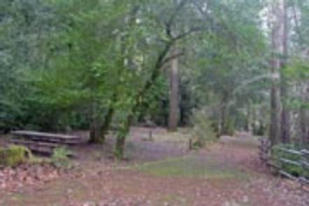
Pearch Creek Campground lies just north of the small town of Orleans in the Klamath river valley of the Six Rivers National Forest. Lush foliage provides welcome shade and relative privacy for each of the campground’s sites.

Recreation

Salmon and steelhead fishing in the nearby Klamath River is considered some of the best in northern California. Both Kalamath and Salmon Rivers are popular destinations for whitewater rafting, swimming and kayaking. Both are within a short drive.

Facilities

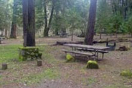
The campground offers several single-family campsites, suitable for both tent and RV-style camping. Each site has picnic tables and campfire rings with grills. Many have rock camp stoves as well. Vault toilets and drinking water are provided.

Natural Features

The campground is located in a mature Douglas fir and hardwood forest. The sound of nearby Pearch Creek can be heard from most sites and the campground remains shady and cool during hot summer days. Moss-covered rocks and tree trunks add to the cooling atmosphere of Pearch Creek.

Nearby Attractions

Trailheads to the Marble Mountain Wilderness

Reservation

More from CampingHiking.net:

SKATERS CABIN SHELTER, Alaska Campground Images, Info & Reservations

Directions This Skater’s Cabin Shelter is approximately 13 miles from downtown Juneau. Access is via the Alaska Marine Highway or via Alaska Airlines. By ferry: Turn right out of the Ferry Terminal parking lot. Drive 1.7 miles to DeHart’s Store above Auk Bay marinas. Take a left turn onto Back

COTTONWOOD POINT, Kansas Campground Images, Info & Reservations

Directions From Marion, Kansas, take Highway 56 for about 4 miles. Turn north on Old Mill Road and continue almost three miles, then follow signs to the campground. Phone 620-382-2101 Activities BOATING, CAMPING, FISHING, HIKING, SWIMMING, WATER ACCESS, ACCESSIBLE SWIMMING Keywords COTP,MARION RESERVOIR,MARION RESERVOIR Related Link(s) Rec Area Info &

INDIAN SPRINGS, California Campground Images, Info & Reservations

Directions From either east bound or west bound Interstate 80, take exit 164 for Eagle Lakes Road. Turn north onto Eagle Lakes Road. Follow the road as it turns west and turn left into the campground. Phone 530-478-6253 Activities CAMPING, FISHING, HIKING, SWIMMING, WATER ACCESS, EDUCATIONAL PROGRAMS, HISTORIC SITES Keywords

SOFTUK BAR CABIN, Alaska Campground Images, Info & Reservations

Directions Access to the cabin is by wheel plane only at low tide, typically a 25-minute flight from Cordova. Click here for local tide tables. Refer to USGS topographic map Cordova A-2. Phone 1 (907) 424-7661 Activities CAMPING, FISHING, HIKING, HUNTING, WILDLIFE VIEWING Keywords SOF1,CHUGACH NF – FS Related Link(s)

WANAKI LOOP, Minnesota Campground Images, Info & Reservations

Directions From Cass Lake, Minn., take U.S. Highway 2 east for 4 miles, to the Norway Beach Recreation Area. Turn left and follow the campground road until the signs indicate the Wanaki Campground. Phone 218-835-4291 Activities BIKING, BOATING, HISTORIC & CULTURAL SITE, CAMPING, INTERPRETIVE PROGRAMS, FISHING, HIKING, SWIMMING SITE Keywords