


Directions
Middle Ridge Cabin is located on Wrangell Island, approximately 20 miles from Wrangell, Alaska. There are no roads to Wrangell. Access is by the Alaska Marine Highway or via Alaska Airlines. From Wrangell, head south on Zimovia Highway approximately 11 miles to Pat’s Creek Road (Road 6259) and take a left. Follow road approximately 4 miles to its junction with Road 50054 and turn right. From this point on, the road becomes steep, exceeding grades of 15 percent, with sharp switchbacks and limited turnouts. Follow Road 50054 about 1.5 miles to its junction with Road 50060, making a sharp right. Stay on Road 50060 for the remaining distance. The cabin is located near the end of Road 50060. Snow can block vehicle access as late as early-June and as early as mid-October in some years. When the road is clear of snow, vehicle access is approximately 20 miles from Wrangell, with portions of the road being gravel with steep grades and tight turns. Access to the cabin requires high-clearance vehicles, or a snowmobile or off-road vehicle in the winter. The road is not suitable for RVs or trailers.
Phone
907-874-2323
Activities
BIKING, CAMPING, FISHING, OFF HIGHWAY VEHICLE, WINTER SPORTS, WILDLIFE VIEWING, SWIMMING SITE, PADDLING, BERRY PICKING
Keywords
MIDDLE RIDGE CABIN (AK),Middle Ridge Cabin,Tongass National Forest,Wrangell Ranger District
Related Link(s)
Overview
Middle Ridge Cabin is wheelchair accessible and located on the Wrangell Island road system. The cabin is open year-round and offers opportunities for both summer and winter recreation. It is unique to Tongass National Forest because it is accessible by vehicle in the summer months from the town of Wrangell, and by snowmobile, off-road vehicle or cross-country skis in the winter. Guests are responsible for their own travel arrangements and safety, and must bring several of their own amenities.
Recreation
Summer opportunities include berry picking, exploring the expansive muskeg, mountain biking on the road system, and sightseeing by vehicle or off-road vehicle. The lake offers opportunities for swimming, small craft boating and fishing. A skiff with oars is provided at the lake, but guests must bring their own personal flotation devices. Hunting for deer or upland birds is possible in the fall, with the proper permits. The landscape is ideal for snowshoeing, cross-country skiing and snowmobiling during the winter months.
Facilities
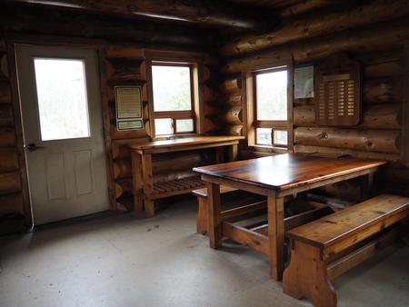
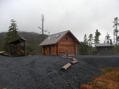
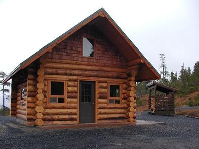
Middle Ridge is a young-growth log cabin constructed of 35- to 40-year-old spruce logs. The logs were hand-scribed and joined together by students in a cabin building class offered at the University of Alaska Southeast-Sitka during May 2009. The logs were then shipped to Wrangell and reassembled at the Middle Ridge Cabin site in September 2009. The 16-by-20 log cabin has one double bunk, one single bunk and a loft to accommodate up to eight people. It is also equipped with a table with benches, a wood stove for heat and counter space for cooking gear. The cabin is fully accessible, with the exception of the sleeping loft. The loft offers floor space for up to four adults. Natural light flows into the loft via two gable-end windows and two skylights. Two picnic tables, an accessible tent platform, a campfire ring and a woodshed with firewood are located outside. An outhouse with accessible toilets is about 40 feet from the front door of the cabin. Wheelchair-friendly pathways connect all outdoor facilities to the cabin. Electricity and water are not provide at the cabin. In addition to water for drinking, cooking and cleaning purposes, guests will need to bring their own cooking gear, sleeping bags and pads, food, toilet paper, garbage bags, cooking gear, matches and flashlights or lanterns ( click here for more cabin details). Guests are expected to pack out all their trash and food, as well as clean the cabin before leaving.
Natural Features
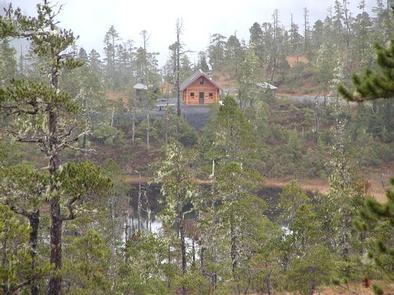
The cabin sits at approximately 1,500 feet in elevation, on a landscape comprised primarily of muskeg. The surrounding forest is a mix of spruce, hemlock, cedar and lodgepole pine. The cabin overlooks a small lake and is surrounded by gently sloping, evergreen-forested mountains. Wrangell Island wildlife includes brown and black bears, moose, porcupines and Sitka black-tailed deer ( bear safety information ). Eagles and a variety of other birds also make their home here.