

Directions
From Pomeroy, take Highway 12 west for about 4 miles. Turn left on Tatman Mt. Road and continue (road changes to Linville Gulch after a couple of miles) for about 6.5 miles (sharp right turn at top of hill) where pavement ends at Blind Grade. Continue on gravel road (Blind Grade) with hairpin turns to stop sign. Turn left onto Tucannon Road and continue for about 8.5 miles. Guard station is on the right.
From Dayton, take Highway 12 east about 11.5 miles, and turn right on Tucannon Road. Continue about 24 miles. The guard station is on the right. This route is best for large RVs and is the best route in winter, especially for those with two-wheel drive vehicles. Please contact the Columbia County Road Department in Dayton for winter road condition reports.
Phone
509-843-1891 MONDAY-FRIDAY 7:30-4:30 CLOSED WEEKENDS & HOLIDAYS
Activities
CAMPING, FISHING
Keywords
TUCANNON GUARD STATION (WA)
Related Link(s)
Washington State Road Conditions
Overview
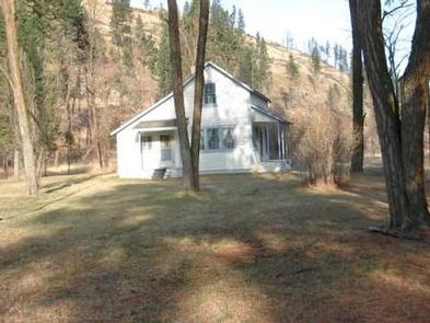
The historic Tucannon Guard Station is a charming saltbox-style cabin constructed in 1909. It was inhabited by the first ranger in the Tucannon area, William Kendell, and his family. By 1916, the guard house became headquarters for the district for two years, and then continued on as a standard guard station.
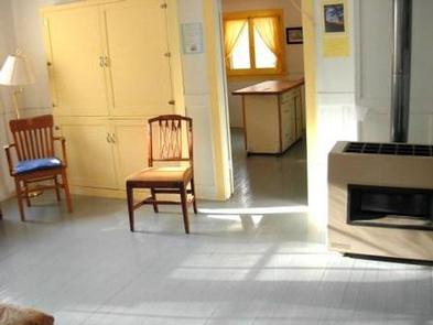
Staying here is like stepping back in time. The rooms inside are nicely decorated and cozy. Touches like curtains on the windows and modern furniture add to the destination experience. Beyond the cabin is plenty of photogenic scenery, plus options for prime fishing and hiking.
Recreation
Just a few miles south are trailheads to wilderness hiking trails. Plus the road along the Tucannon River is a notable scenic drive, ideal for viewing flora and fauna.
Facilities
Tucannon is a two-story wood frame structure with wood siding and a shake shingle roof. The upstairs is divided into two sleeping areas, one furnished with a bunkbed and a single bed and the other with a double bed. The ground floor has a spare ˜museum room with historic pictures and a living room furnished with a futon that sleeps two. The downstairs bathroom is equipped with a flush toilet and shower/tub with hot water.
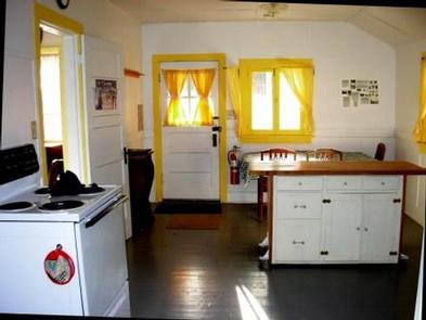
Electricity and propane are included for heating and cooking. The kitchen and dining area boast a cook stove and refrigerator, plus a table and chairs. The cabin has potable running water year round. A picnic table beneath the trees & firepit sit outside.
Most cleaning supplies, dishes, pots, pans and utensils are provided, but visitors are encouraged to bring their own. Guests should also bring bedding or sleeping bags, and basic camping gear like flashlights, dish soap and matches. Cabin should be cleaned before departure. Mop, bucket, broom and cleaning supplies provided.
Natural Features
The cabin is at 2600 ft elevation on a shady, gently rolling site at the base of a hillside in Tucannon Valley. The rugged landscape stretches across the northern Blue Mountains of southeastern Washington and northeastern Oregon.
Visitors may spot local inhabitants like wild turkey, pheasant, deer, elk and even an occasional moose in the area.
Nearby Attractions
A convenience store, gas station and RV park is located about 9 miles, or 15 minutes, north of the cabin. River access and opportunities for hunting and mushroom picking are also within 10 miles of the cabin.