


Directions
From Exit 6 in St. George, Utah, turn north onto Bluff Street, which turns into Utah Highway 18 North; continue to follow for 27 miles. Turn east onto Pine Valley Highway and travel 6.9 miles into Pine Valley. From the Pine Valley stop sign, turn east onto Main Street and follow 2 miles to the Pine Valley Recreation Area. The Guard Station is located a quarter mile past the reservoir parking lot on the north side of the road.
During winter months, there is a 1.5 mile cross-country ski, snowshoe or walk into the cabin from the winter trailhead at the entrance to the Pine Valley Recreation Area.
Phone
435-652-3100
Activities
BIKING, CAMPING, HIKING, WINTER SPORTS, WILDLIFE VIEWING, BIRDING, CROSS COUNTRY SKIING, AMPHITHEATER, SNOWSHOEING
Keywords
None
Related Link(s)
Overview
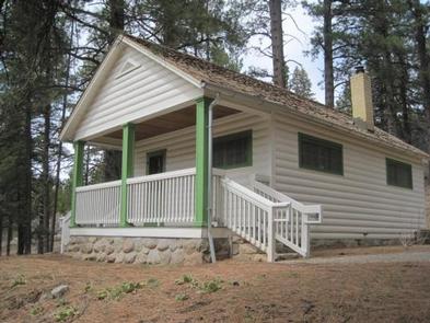
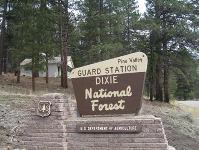
Pine Valley Guard Station is located in scenic Pine Valley Recreation Area, about 45 minutes from St. George, Utah. Built in 1935 by the Civilian Conservation Corps, the station was used to house a recreation guard during the summer months to assist the visiting public.
The cabin is open year-round and is accessible by vehicle during good road conditions. Winter use of the cabin may require snowshoeing, hiking or cross-country skiing about 1.5 miles from the trailhead at the entrance to the Pine Valley Recreation Area.
Many modern amenities are offered, including electricity. Guests only need to bring a few of their own supplies to have a truly comfortable stay in this charming retreat within the Dixie National Forest.
Recreation
The cabin is centrally located within the Pine Valley Recreation Area, in close proximity to fishing at Pine Valley Reservoir. This small, quiet reservoir offers a scenic location to fish for rainbow trout.
Numerous non-motorized trails provide access into the Pine Valley Mountain Wilderness. Mountain biking is a popular activity outside of the wilderness area.
The winter landscape provides opportunities for snow tubing, snowshoeing and cross-country skiing.
Facilities
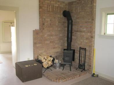
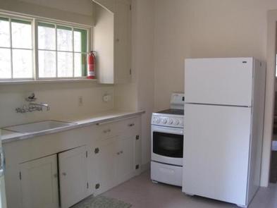
The cabin retains most of the historical qualities of the original building, with the added feature of electricity. Six people can sleep comfortably on one futon and one set of double/twin bunk beds with mattresses. A wood burning stove is provided for heat, along with firewood. The kitchen is equipped with an electric range, refrigerator, lights, cookware, dishes and utensils. Indoor plumbing is available in the summer months, offering guests access to a shower and flush toilet.
Guests can enjoy outdoor cooking on the campfire ring with grill. An outhouse is provided for year-round use. Water is only available during the summer months. Guests will need to bring their own supply of water for drinking, cooking and washing during the winter.
Guests should pack sleeping bags, pillows, flashlights, matches, toilet paper, a first aid kit and garbage bags. All food and trash must be packed out, and guests are expected to use the provided cleaning supplies to clean the cabin before leaving.
Natural Features
The cabin is surrounded by ponderosa pine trees and offers scenic views of the Pine Valley Mountains. At an elevation of 6,800 feet, summer days are warm and nights are cool.
The nearby Pine Valley Mountain Wilderness, described as a mountain island surrounded by desert, preserves numerous lush meadows and a beautiful forest of Engelmann spruce in the south, and spruce mixed with fir, pine and large stands of aspen in the north.
The Pine Valley Mountains rise through the entire center of the Pine Valley Wilderness, providing habitat for chipmunks, marmots, red squirrels, blue grouse and a large herd of deer in summer. Elevations rise to a high point at 10,365 feet on Signal Peak in the southern portion.