Laurel River Lake Picnic Area, KY Campground Reservation, Info, Images, Map, Directions

Laurel River Lake Picnic Area, Kentucky Campground Images, Info & Reservations

Directions

From London, Kentucky, head west on HWY 192 for approximately 15 miles. Turn slight left onto KY-1193. Continue on KY-1193 until arrive at destination on left. Area is marked by "Laurel Dam Picnic Area" signs.

Phone

606-864-6412

Activities

HIKING, SWIMMING SITE

Keywords

Laurel River Lake Picnic Area,Laurel Picnic Area

Related Link(s)

Rec Area Info & Images

Kentucky State Road Conditions

Kentucky State Tourism

Overview

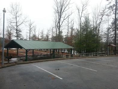
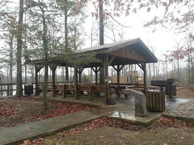
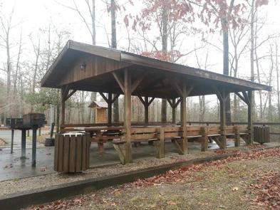
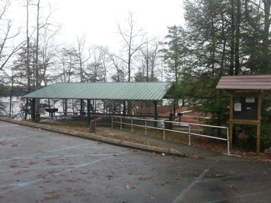
Laurel River Lake Picnic Area is a day-use facility located on a peninsula along the shores of Laurel River Lake. The picnic area provides 19 individual picnic sites which are first-come, first-serve, and two reservable shelters. There is no overnight camping allowed in the area.

Click here for the Laurel River Lake Picnic Area virtual tour.

Recreation

Laurel River Dam was completed in 1974 creating a 5,600-acre lake which provides hydroelectric power, safe drinking water and recreation opportunities for the public. Since its impoundment, the Forest Service and the Army Corps of Engineers have cooperated in developing public recreation facilities on and around the lake.

Facilities

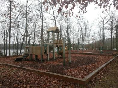
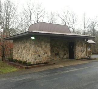
Laurel River Lake Picnic Area offers one small and one large reservable group picnic shelter, with 19 additional picnic sites with tables and grill. Flush toilets, drinking water, playground, horseshoe pit, fishing pier and a volleyball net are also provided.

Natural Features

Laurel River Lake, with its cliff-lined shores and quiet coves, is a favorite destination for thousands of visitors each year. They come to boat, canoe, fish, hunt, hike, camp, swim, scuba dive, view wildlife and relax at one of the deepest and cleanest lakes in Kentucky.

Nearby Attractions

Less than a mile up the road is a 725-feet long sandy beach area with a parking lot and chemical treated toilets. The beach is unguarded so always wear a flotation device when you’re on or in the water. While visiting the picnic area you can stay at one of the Forest Service drive-in campgrounds located at Holly Bay and Grove Recreation Areas. Whiteoak and Grove boat-in campgrounds are accessible only by boat or trail. Cumberland Falls is the second largest waterfall east of the Rockies. It is about a 20 mile drive from the area. Cumberland Falls State Park provides lodge and cabin accommodations for guests.

Reservation

More from CampingHiking.net:

MAHOGANY GROVE, Nevada Campground Images, Info & Reservations

Directions From Las Vegas, Nevada, take Highway 95 north to the junction with Highway 157/Kyle Canyon. Turn left and travel approximately 18 miles to junction with Highway 158/Deer Creek. Turn right and travel approximately 6 miles to the campground. Phone 702-872-5486 Activities CAMPING Keywords MAHO,MOUNT CHARLESTON,LAS VEGAS,SPRING MTNS NAT REC

UPPER STAMP CREEK CG, Georgia Campground Images, Info & Reservations

Directions From I-75 take exit 290 and head east on Highway 20 toward Canton/Rome. After 4 miles, turn right onto Wilderness Camp Road, then take a left onto Chitwood Cemetery Road and follow the signs to the campground. Physical address: 80 Chitwood Cove Road White, GA 30184 Phone 678-721-6700 Activities

HELLS CROSSING CAMPGROUND, Washington Campground Images, Info & Reservations

Directions From Naches, take Highway 410 approximately 38 miles northwest to milepost 83.4. Phone 541-338-7869 Activities CAMPING, FISHING, HIKING, WATER SPORTS, SWIMMING SITE Keywords HECR,OKANOGAN – WENATCHEE NF -FS,HELLS CROSSING,HELLS CROSSING CAMPGROUND Related Link(s) Rec Area Info & Images Washington State Tourism Forest Service Concessionaire Washington State Road Conditions Overview

SILVER CREEK-TRUCKEE, California Campground Images, Info & Reservations

Directions From Truckee, travel south on Highway 89 for about 8 miles. Campground is on the left. Phone (530)587-3558. FOR RESERVATIONS, PLEASE CALL: 1 (877) 444-6777. Activities BIKING, CAMPING, FISHING, HIKING, SWIMMING SITE, MOUNTAIN BIKING, WATER ACTIVITIES, WATER ACCESS Keywords SICR,SILVER CREEK TRUCKEE,TAHOE NF – FS Related Link(s) Rec Area

SHERWOOD CAMPGROUND, Oregon Campground Images, Info & Reservations

Directions From I-84 at Hood River, head south on highway 35 toward Mt. Hood. Just past the Tamanawas Falls trailhead parking, the Sherwood Campground is on the right. Phone 541-386-6366 Activities CAMPING Keywords Related Link(s) Rec Area Info & Images Oregon State Road Conditions Oregon State Tourism Overview Sherwood campground

TWIN CREEKS PICNIC PAVILION, Tennessee Campground Images, Info & Reservations

Directions From downtown Gatlinburg Tennessee, Turn south at stoplight #8 in Gatlinburg. Follow Historic Nature Trail Road to 4-way junction at access road to Park Vista Hotel. Go straight and continue 1.4 miles into the Park. turn right at Twin Creeks sign. Phone 865-436-1261 Activities CAMPING, FISHING, HIKING, WILDLIFE VIEWING,