PHILLIP'S CREEK GROUP PICNIC AREA, VA Campground Reservation, Info, Images, Map, Directions

PHILLIP’S CREEK GROUP PICNIC AREA, Virginia Campground Images, Info & Reservations

Directions

From the intersection of US 23 and State Route 671 (about 1.25 miles west of Pound, VA) go west on State Route 671 for approximately 5.3 miles. Turn right into the Phillips Creek Recreation Area. Go for about 0.4 miles to the picnic area.

Phone

276-679-8370

Activities

FISHING, HIKING, KAYAKING, CANOEING

Keywords

North Fork of Pound Picnic Area

Related Link(s)

Rec Area Info & Images

Virginia State Road Conditions

Virginia State Tourism

Overview

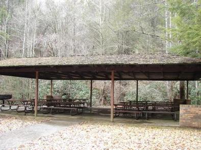
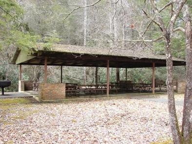
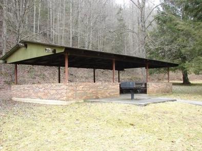
Phillips’s Creek Group Picnic area is a secluded site surrounded by forest. It is a great facility for family reunions, organization activities and other group events.

Recreation

Open lawn areas are adjacent to the picnic area can be used for activities such as horseshoes, sports and games (bring your own game and sports equipment). Hiking trails are available within easy driving distance and include Pine Mountain and Red Fox Trails. The Phillip’s Creek Trail is near the picnic area.

Facilities

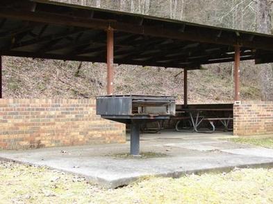
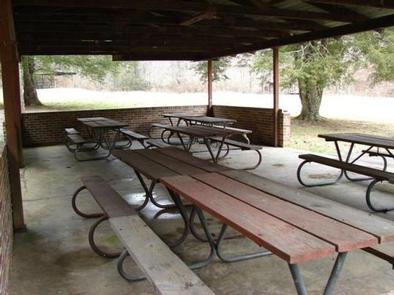
Parking is adjacent to the picnic shelters and restroom facilities. The restrooms are pit toilets. The toilets are adjacent to shelter #1 but are a short walk (850 feet) from shelter #2. A large charcoal grill is available at both shelters. Picnic tables are located inside the shelters. There is no electricity or drinking water available.

Natural Features

The picnic area is surrounded by forest. The North Fork of Pound Reservoir is nearby and is a popular boating and fishing destination.

Nearby Attractions

The Pine Mountain and Red Fox Trails are within easy driving distance.

Reservation

More from CampingHiking.net:

LUPINE, California Campground Images, Info & Reservations

Directions From Highway 41, take Bass Lake turnoff, head southeast approximately 3.5 miles to the Bass Lake office. Continue approximately 2.75 miles to the Lupine Cedar Bluff Campground. Phone 559-642-3212 Activities BOATING, CAMPING, INTERPRETIVE PROGRAMS, FISHING, HIKING, WATER SPORTS, SWIMMING SITE Keywords LUPE,CEDAR-LUPINE,BASS LAKE,SIERRA NF – FS Related Link(s) Rec

INTERROREM CABIN, Washington Campground Images, Info & Reservations

Directions Travel approximately 22 miles north of Hoodsport on Highway 101 to the Duckabush Recreation Area, turn west (left) onto the Duckabush River Road (Forest Service Road #2510). Follow the Duckabush Road for 4 miles to the end of the pavement. Interrorem Cabin is on the left side of the

KATY BRANCH, Tennessee Campground Images, Info & Reservations

Directions From Greeneville travel east to 11E to TN State Road 107. Travel approximately 14.5 miles to the gate at Katy Branch located on the right. (Landmarks will include Clark Creek Road on the right and Jackson Bridge Road on the left.) Unlock the gate and travel about .5 miles

RUDDS CREEK REC. AR., Virginia Campground Images, Info & Reservations

Directions The physical location for Rudd’s Creek Park is: 16064 Highway 58, Boydton, VA 23917. It is located about 3 miles west of Boydton, VA. Phone IN RECREATION SEASON ONLY: (434) 738-6827; ALL OTHER INQUIRIES CALL VISITOR ASSISTANCE CENTER: (434) 738-6143 Activities BOATING, CAMPING, FISHING, HIKING, HUNTING, DAY USE AREA,

COTTONWOOD CAMPGROUND (WA), Washington Campground Images, Info & Reservations

Directions From Naches, take Highway 410 northeast 22.5 miles to milepost 99.5. Phone 541-338-7869 Activities CAMPING, FISHING, HIKING, WATER SPORTS Keywords CTWD,OKANOGAN – WENATCHEE NF -FS,COTTONWOOD,COTTONWOOD CAMPGROUND Related Link(s) Rec Area Info & Images Washington State Tourism Washington State Road Conditions Forest Service Concessionaire Overview Cottonwood Campground is located along