ELEPHANT ROCK CAMPGROUND, NM Campground Reservation, Info, Images, Map, Directions

ELEPHANT ROCK CAMPGROUND, New Mexico Campground Images, Info & Reservations

Listen

Directions

The campground is located 12 miles east of Questa, New Mexico via NM highway 38 or 3 miles west of Red River, New Mexico via NM highway 38.

Phone

435-245-6521

Activities

BIKING, CAMPING, FISHING, VISITOR CENTER

Keywords

Related Link(s)

Rec Area Info & Images

New Mexico State Road Conditions

New Mexico State Tourism

Overview

Elephant Rock Campground has excellent fishing access to the well-stocked Red River, nearby Eagle Rock Lake and hiking into the surrounding high country. This campground is close to the highway with plenty of large pine trees. The campground rests at 8,400 feet above sea level.

Recreation

The nearest hiking trail, Fawn Lakes Trail, is located .3 miles east of Elephant Rock Campground, near Fawn Lakes Campground. This trail meets accessibility guidelines. Elephant Rock offers convenient access to State Rt. 38 and is well situated for day trips on the Enchanted Circle and to the town of Red River. The Red River is across the road from the campground but is not accessible.

Facilities

This campground offers 20 single sites, potable water, and vault toilets. Each site has a fire ring, picnic table, and tent pad.

Natural Features

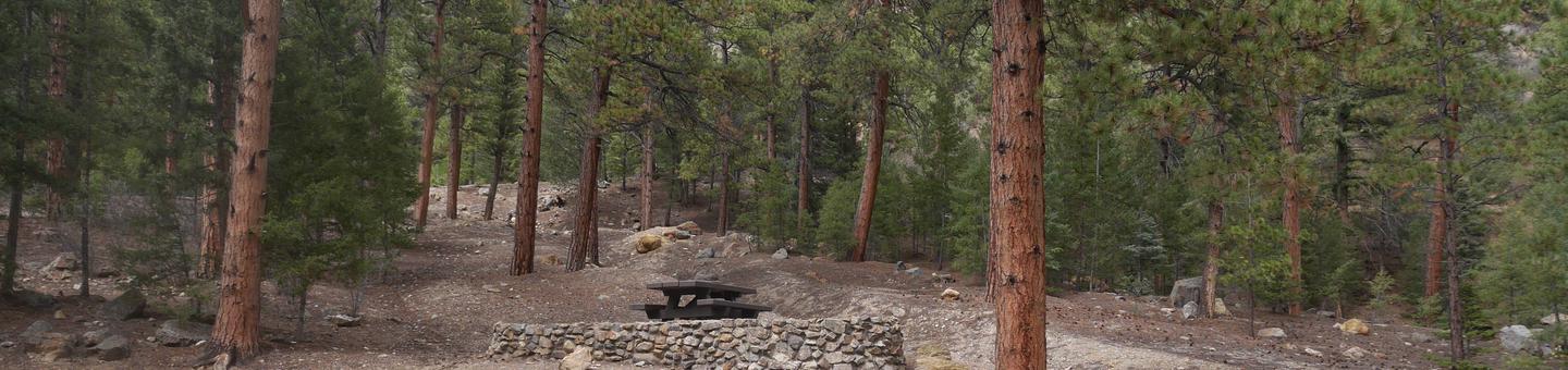
Elephant Rock Campground is a single loop that meanders up a hillside with several sites featuring stone terracing. The campsites are tucked in among a mixture of ponderosa pine, aspen, fir and spruce. The Red River flows near this campground.

Nearby Attractions

Visitors to the area can explore the town of Red River, Questa, and the Enchanted Circle.

Reservation

More from CampingHiking.net:

WESTCLIFF, Texas Campground Images, Info & Reservations

Listen Directions From Interstate 35 in Belton, Texas take the 294 exit (6th Avenue or Farm-to-Market Road 93) west. Turn north onto 317 (Main Street) and drive for two miles. Turn west on FM 439 (Lake Road) and go four miles. Turn right on Sparta Road, then take a right

CAMP MISTY MOUNT, Maryland Campground Images, Info & Reservations

Listen Directions The street address for GPS use is 14764 Park Central Road, Thurmont, MD. From Washington DC, take the George Washington Memorial Parkway north to I-495 onto I-270 north 27 miles to Frederick, MD. Take Route 15 for 17 miles north to Thurmont, MD. Take Route 77 West, the

HEYBURN PARK, Oklahoma Campground Images, Info & Reservations

Listen Directions From Bristow, go 9 miles east and turn left on to 257th West Ave. Follow the paved road about 3 miles to the campground. From Sapulpa, take State Highway 66 west to Kellyville, turn west on to 151st South Ave and go about 3.5 miles to the 4

The Ledge Group Sites, Utah Campground Images, Info & Reservations

Listen Directions From Moab, drive 10 miles on the Kane Creek Road. The group site is on the left hand side of the road. Phone 435-259-2100 Activities CAMPING, HIKING, PHOTOGRAPHY, MOUNTAIN BIKING, SCENIC DRIVE Keywords Related Link(s) Rec Area Info & Images Utah State Tourism Utah State Road Conditions Overview

SILVER CREEK-TRUCKEE, California Campground Images, Info & Reservations

Listen Directions From Truckee, travel south on Highway 89 for about 8 miles. Campground is on the left. Phone (530)587-3558. FOR RESERVATIONS, PLEASE CALL: 1 (877) 444-6777. Activities BIKING, CAMPING, FISHING, HIKING, SWIMMING SITE, MOUNTAIN BIKING, WATER ACTIVITIES, WATER ACCESS Keywords SICR,SILVER CREEK TRUCKEE,TAHOE NF – FS Related Link(s) Rec

ANAN BAY CABIN, Alaska Campground Images, Info & Reservations

Listen Directions This cabin is on the mainland at Anan Bay, across Ernest Sound from the southeast corner of Wrangell Island. The site is 27 miles by air from Wrangell, and is accessible by boat and float plane. There is a 40-foot mooring float anchored in the bay for use