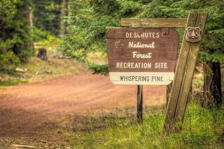
Whispering Pines Horse Camp, OR Campground Reservation, Info, Images, Map, Directions

Whispering Pines Horse Camp, Oregon Campground Images, Info & Reservations

Directions

From Sisters, OR:Travel approximately 6 miles west on Highway 242 (McKenzie Pass Highway) then follow the signs into Whispering Pine Horse Camp.

Phone

541-323-1746

Activities

CAMPING

Keywords

Related Link(s)

Rec Area Info & Images

Oregon State Road Conditions

Oregon State Tourism

Overview

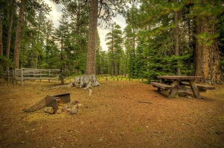
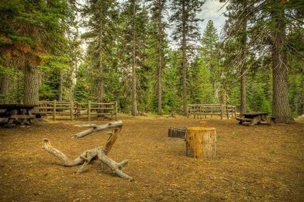
Located eleven miles west of Sisters, Oregon, off Highway 242, Whispering Pine Horse Camp provides early season access to trails and is perfect for horse lovers who are visiting nearby friends. This rustic nine site horse camp offers great riding opportunities and trail access to the Three Sisters Wilderness Area.

Recreation

This campground offers many opportunities for horseback riding or hiking with the many trails nearby. The pine forest provides shade as well as the chance to go bird or nature watching.

Facilities

There are nine sites in this campground and each can accommodate up to four horses. Livestock water is available as well as vault toilets, but campers will need to bring their own drinking water.

Natural Features

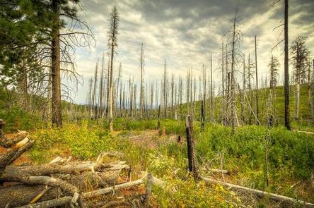
Whispering Pine Horse Camp is nestled below a thick ponderosa pine forest mixed with birch in the wet areas. The pines provide nice shade and the chance to enjoy the quiet of nature.

Nearby Attractions

The close proximity to the town of Sisters offers many additional amenities and attractions, such as well as the nearby Camp Sherman RV Park as well as the Windigo Trail and Sisters Wilderness Trails.

Reservation

More from CampingHiking.net:

TURKEY CREEK, Oklahoma Campground Images, Info & Reservations

Directions From Broken Bow, OK, travel Highway 3 west for 28 miles to the entrance sign. Follow access road north 5 miles to the campground. Phone 580-876-3720 Activities BOATING, CAMPING, FISHING Keywords TURK,PINE CREEK LAKE,PINE CREEK LAKE Related Link(s) Rec Area Info & Images Oklahoma State Road Conditions Oklahoma State

BEAR CREEK CABIN, Montana Campground Images, Info & Reservations

Directions From Ennis, take Highway 287 south for 11 miles, to Cameron, Montana. From Cameron, turn east on Bear Creek Loop and continue approximately 6 miles to the cabin. The last several miles are gravel or dirt roads, which may be muddy or snow-covered and may not always be plowed.

HAUSER SAND CAMPING, Oregon Campground Images, Info & Reservations

Directions From North Bend Oregon, travel North on Highway 101 for 6 miles to Hauser Depot Road. Turn left on Hauser Depot Road and proceed 1/4 mile. Turn left over the railroad tracks onto Sandy Way. Proceed 1/3 mile to the Hauser sand access. To access sand camps #86-#98 turn

FRUITA CAMPGROUND, Utah Campground Images, Info & Reservations

Directions Traveling westbound on Interstate 70: Take Utah State Highway 24 west towards Hanksville (exit 149). Stay on Highway 24 for 80 miles to reach the park Visitor Center. Traveling on Interstate 15: Take US Highway 50 east at Scipio (exit 188) towards Salina for 30 miles. At the junction

KIMBALL BEND PARK, Texas Campground Images, Info & Reservations

Directions From Kopperl, TX, travel north on HWY 56 for approximately 2.5 miles. Turn right on HWY 174 and go approximately 2.3 miles. Turn left into the park, just before the HWY 174 bridge. From Cleburne, TX, travel south on HWY 174 for 22 miles. Turn right into the park

PINEY BAY, Arkansas Campground Images, Info & Reservations

Directions From London, Arkansas, take US-64 west for 3 miles to State Route 359 north. Continue for 3.5 miles and follow signs into the campground. Phone 479-885-3029 Activities BOATING, CAMPING, FISHING, DAY USE AREA, SWIMMING SITE Keywords PINB,DARDANELLE LAKE-ARK. RIV.NAV.,DARDANELLE LAKE Related Link(s) Rec Area Info & Images Arkansas State