Corbin's Island Picnic Shelter, PA Campground Reservation, Info, Images, Map, Directions

Corbin’s Island Picnic Shelter, Pennsylvania Campground Images, Info & Reservations

Directions

From Huntingdon follow Route 22 eastbound and turn right onto Point Road just past the Giant Food Store. Continue on Point Road (staying left) approximately 6.3 miles. The Corbin’s Island access will be on your left.

Phone

814-658-3405

Activities

BOATING, CAMPING, FISHING, HUNTING, WATER SPORTS, SWIMMING SITE

Keywords

Corbin’s Island

Related Link(s)

Rec Area Info & Images

Pennsylvania State Tourism

Pennsylvania State Road Conditions

Overview

Corbin’s Island Recreation Area is located at the northern end of Raystown Lake, just downstream from the Raystown Dam. The recreation area is easily accessible from US Route 22 and offers a great location for picnicking, fishing, and floating down the river.

Recreation

Raystown Dam, Ridenour Overlook and Hawn’s Overlook are three beautiful overlook areas that are within a 10 minute drive from Corbin’s Island. A boat ramp within the facility provides access for small fishing boats, kayaks, canoes and tubes.

Facilities

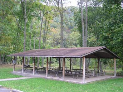
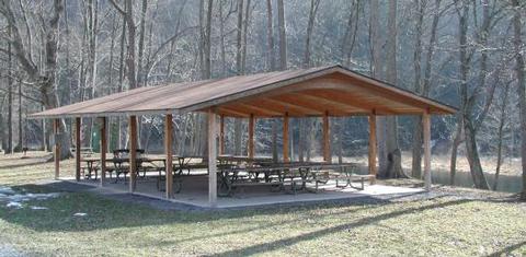
Corbin’s Island offers one group shelter with approximately 10 tables and 20-amp electrical service. It is fully accessible and comfortably accommodates up to 80 people in a lovely river setting.

Natural Features

Corbin’s Island is situated along the shady banks of the Raystown Branch of the Juniata River. Nearby access to the cool, flowing waters of the Raystown Branch makes this shelter a great place to picnic, fish and float the river all in one day.

Nearby Attractions

The area offers Snyder’s Run Boat Launch, Seven Points Recreation Area, Seven Points Marina and access to downtown Huntingdon.

Reservation

More from CampingHiking.net:

AUK VILLAGE CAMPGROUND, Alaska Campground Images, Info & Reservations

Directions From the cruise ship terminal on South Franklin Street in downtown Juneau, head northwest along the waterfront. South Franklin Street becomes Marine Way, then Egan Drive, named for William A. Egan (1914 – 1984), first governor of the State of Alaska. Egan Drive becomes Glacier Highway at Milepost 9.4,

Caesar Creek Lake, Ohio Campground Images, Info & Reservations

Directions From I-75 head east on Highway 73 for 11.5 miles past Waynesville. Follow the signs for the Caesar Creek Visitor Center for 3 more miles. From I-71 head west on Highway 73 for 7.7 miles. Follow the signs for the Caesar Creek Visitor Center for about 3 miles. Phone

Beckler River Campground, Washington Campground Images, Info & Reservations

Directions From Seattle, Washington, go north on I-5 to US Highway 2, exit 194. Approximately 49 miles along Highway 2 turn north onto Forest Road 65. Turn at the campground sign and continue about 1.5 miles. Phone 360-419-5115 Activities BIKING, BOATING, CAMPING, FISHING, HIKING, HUNTING, WILDLIFE VIEWING Keywords BECR,MT. BAKER-SNOQU

SPRING CREEK CAMPGROUND, Idaho Campground Images, Info & Reservations

Directions From Weiser, Idaho, travel north on Highway 95 for approximately 12 miles, then turn onto Upper Mann Creek Road/Forest Road 009 and travel another 18 miles to the campground. Phone 208-549-4200 Activities BIKING, CAMPING, FISHING, HIKING, HUNTING, WILDLIFE VIEWING, DAY USE AREA Keywords SPCK,SPRING CREEK GROUP SITE,SLEEPING SPRINGS INTERPRETATION,PAYETTE

BRUSHY CREEK DAY USE, Texas Campground Images, Info & Reservations

Directions From Jefferson, Texas, travel 3.8 miles northwest on Highway 49. Turn left onto FM 729 and continue for 3.5 miles, then turn left again onto FM 726. Travel 5.0 miles turn right at the stop sign and follow signs to the park entrance. Phone 903-777-3383 Activities BOATING, FISHING, WILDLIFE