Weaver Falls Shelter, PA Campground Reservation, Info, Images, Map, Directions

Weaver Falls Shelter, Pennsylvania Campground Images, Info & Reservations

Directions

Weaver’s Falls is located near the town of Saxton, PA. From Saxton follow PA913 east 1.0 mile then turn left onto SR31019 (look for signs). Travel 2.0 additional miles crossing Weaver’s Bridge and the Weaver’s Falls Recreation Area will be on the right.

Phone

814-658-3405

Activities

BOATING, CAMPING, FISHING, HUNTING

Keywords

Weaver’s Falls Shelter,Weaver’s Falls,Weaver Falls

Related Link(s)

Rec Area Info & Images

Pennsylvania State Tourism

Pennsylvania State Road Conditions

Overview

Weaver’s Falls Recreation Area is located at the south end of Raystown Lake. The recreation area is accessible from PA Route 913 and offers a great location for picnicking and fishing.

Recreation

A boat ramp within the facility provides access to the 8,300-acre Raystown Lake, which is popular for boating, camping and fishing. There is also a playground for the kids adjacent to the shelter.

Facilities

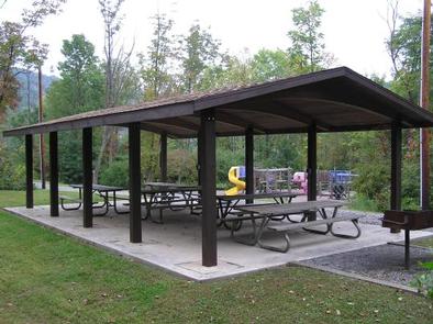
Weaver’s Falls offers one group shelter with approximately 10 tables, but there is no electricity available. The shelter is fully accessible and comfortably accommodates up to 80 people with a view of the lake.

Natural Features

Weaver’s Falls is situated along the main lake channel at the southernmost end of Raystown Lake. Nearby access to the lake makes this shelter a great place to picnic, fish and launch a boat all in one day.

Nearby Attractions

The area offers Aitch Boat Launch, James Creek Boat Launch, Tatman Run Recreation Area, Lake Raystown Resort, Seven Points Recreation Area, Seven Points Marina and Heritage Cove Resort.

Reservation

More from CampingHiking.net:

KEYESPORT REC. AREA, Illinois Campground Images, Info & Reservations

Directions From I-70, take State Route 127 south for 10 miles. Turn east on Clinton Road, continue east for four miles to the town of Keyesport, then follow signs to the recreation area. Phone 618-594-5253 Activities BOATING, CAMPING, FISHING, SWIMMING SITE Keywords KEYS,CARLYLE LAKE Related Link(s) Rec Area Info &

Grandview Shelter 1, West Virginia Campground Images, Info & Reservations

Directions To reach Grandview from Beckley follow I-64 East five miles to Exit 129 B. From Lewisburg follow I-64 West forty miles to Exit 129. From either exit, turn right and follow Route 9 North six miles to Grandview. Phone 304-465-0508 Activities HIKING, PICNICKING, DAY USE AREA Keywords Grandview State

ALPINE VIEW CAMPGROUND, California Campground Images, Info & Reservations

Directions From Weaverville: take Highway 3 north for 22.5 miles. Turn right on Guy Covington Road for 2.4 miles to the campground. Phone 530-275-8113 Activities CAMPING, FISHING, HIKING, WATER SPORTS Keywords Trinity Lake,Alpine View Related Link(s) Rec Area Info & Images California State Road Conditions Forest Service Concessionaire California State

ALMANOR, California Campground Images, Info & Reservations

Directions From Chester, take Highway 36 west to Highway 89 South. Turn left on Highway 89 and continue south about 6 miles, to Almanor Drive West (not to be confused with Almanor West development and Almanor West Drive). Turn left on Almanor Drive West (directly across from the Almanor Group