CASTLE ROCK GROUP CAMPGROUND, OR Campground Reservation, Info, Images, Map, Directions

CASTLE ROCK GROUP CAMPGROUND, Oregon Campground Images, Info & Reservations

Directions

From Hebo, Oregon travel south on Highway 22, 4.2 miles. Location is on the right.

Phone

503-392-5100

Activities

HIKING, SWIMMING

Keywords

Related Link(s)

Rec Area Info & Images

Oregon State Tourism

Oregon State Road Conditions

Overview

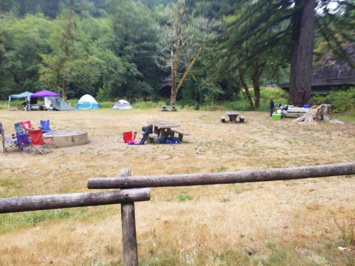
Located on Three Rivers, this group campground is ideal for family gatherings and group arrangements. Conveniently located off Hwy. 22 and surrounded by forest, it provides a picturesque setting to enjoy a fun filled, group camping experience.

Recreation

Campground offers an open space style group camping experience. The river provides opportunities for fishing or summer swimming, and hiking trails are within a few miles from the site.

Facilities

The group site includes eight picnic tables, group fire ring, individual rock fire pits, one vault toilet, garbage dumpster and a parking area.

Natural Features

Open grassy meadow surrounded by forests, rivers, and coastal mountains, this campground offers a picturesque setting to gather, camp, fish, and play.

Reservation

More from CampingHiking.net:

COVERED BRIDGE, New Hampshire Campground Images, Info & Reservations

Directions From Conway, New Hampshire: Take Kancamagus Highway (State Route 112), 6 miles west, then turn on Dugway Road and proceed into the campground. Vehicles 7’9" or taller are unable to pass through due to height restriction for the covered bridge and must use an alternate route: At traffic light

SAM OWEN, Idaho Campground Images, Info & Reservations

Directions From Sandpoint, take State Highway 200 east 21 miles. Turn right on Peninsula Road (County Road 1028) and continue 1 mile to the recreation area. Phone 435-245-6521 Activities BOATING, CAMPING, DAY USE AREA, SWIMMING SITE Keywords SAMO,LAKE PEND ORELLIE,SANDPOINT,IDAHO,HOPE,IDAHO,HIGHWAY 200,SKIPPING STONE,SCENTED LEAF,RED SUN,DANCING SHADOWS,IDAHO PANHANDLE NF – FS Related

FRUITA CAMPGROUND, Utah Campground Images, Info & Reservations

Directions Traveling westbound on Interstate 70: Take Utah State Highway 24 west towards Hanksville (exit 149). Stay on Highway 24 for 80 miles to reach the park Visitor Center. Traveling on Interstate 15: Take US Highway 50 east at Scipio (exit 188) towards Salina for 30 miles. At the junction

LAKESIDE DAY USE, Texas Campground Images, Info & Reservations

Directions From Jefferson, Texas, travel 3.8 miles northwest on Highway 49. Turn left onto FM 729 and continue for 3.5 miles, then turn left again onto FM 726. Travel 3.5 miles the park entrance will be on the right. Phone 903-665-2336 Activities BOATING, FISHING, PICNICKING, WATER SPORTS, WILDLIFE VIEWING, DAY