CHIMNEY LOOP CAMPGROUND, MI Campground Reservation, Info, Images, Map, Directions

CHIMNEY LOOP CAMPGROUND, Michigan Campground Images, Info & Reservations

Directions

From Grayling:
Travel east on M-72 for 30 miles.
Turn right and travel south on M-33 for 7 miles.
Turn right and travel west on Wagner Lake Rd. for 1.5 miles.
The site is located on the left.

Phone

989-826-3252

Activities

CAMPING

Keywords

Related Link(s)

Rec Area Info & Images

Michigan State Tourism

Michigan State Road Conditions

Overview

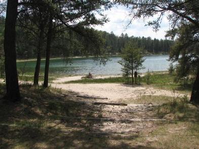
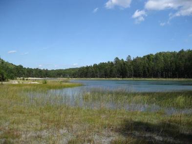
Chimney Loop Campground is located on the shores of Wagner Lake. Wagner Lake is a shallow sandy bottom lake that is entirely surrounded by National Forest. The lake has excellent bass and pan fish fishing. Chimney Loop campground can accommodate groups of up to 30 people and six cars.

Recreation

Popular recreation activities at Chimney Loop Campground include canoeing, kayaking and fishing on Wagner Lake as well as, day trips on the AuSable River located just a few miles to the North.

Facilities

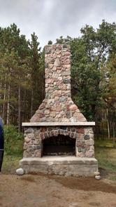
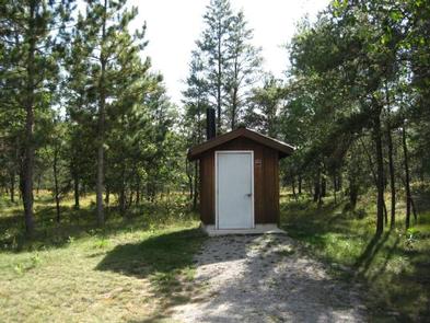
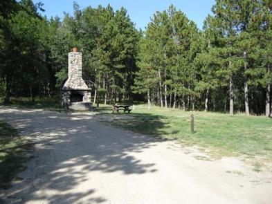
Facilities at Chimney Loop Campground include a vault toilet, three picnic tables, three fire rings, use of a historic chimney, garbage service and drinking water is provided around the corner at Wagner Lake Campground.

Natural Features

The group site is a very short walk from the shores of Wagner Lake in a forest of oak and pine. Chimney Loop Campground is located just a short drive from the AuSable River and is close to ORV trails, however there is no ORV trail access from the campground. ORVs must stay loaded and be transported to the nearby M-33 ORV Trailhead.

Reservation

More from CampingHiking.net:

PARKSIDE, Montana Campground Images, Info & Reservations

Directions From U.S. Highway 212, turn off at Rock Creek Road (Forest Road 2421). Go 0.3 miles to the campground entrance on the right. Phone 406-587-9054 Activities BIKING, BOATING, CAMPING, FISHING, HIKING Keywords PKSD,CUSTER NF – FS Related Link(s) Rec Area Info & Images Overview Parkside Campground is located 12

CEDAR CREEK (TN), Tennessee Campground Images, Info & Reservations

Directions From Nashville, TN. Travel East on I-40 to exit 221A. Continue onto TN-45/Old Hickory Blvd. Turn right onto US-70/Lebanon Pike. Turn left onto Nonaville Road and travel until reaching a 4-way stop. Turn right at the 4-way stop onto Saundersville Road. The recreation area will be at the end

HIGHWAY K, Missouri Campground Images, Info & Reservations

Directions From Annapolis, MO, follow MO Highway K west for 5 miles. The park will be on the left, and is on both sides of the bridge. Phone 573-223-7777 (CLEARWATER LAKE PROJECT OFFICE) 573-558-2202 (HIGHWAY K GATEHOUSE) Activities BOATING, CAMPING, FISHING, SWIMMING SITE Keywords HIGW,CLEARWATER LAKE,CLEARWATER LAKE Related Link(s) Rec

BUCKHORN PAVILION, Oklahoma Campground Images, Info & Reservations

Directions From I-35, take Exit #55 or #51 and drive towards the city of Davis, OK. Once in Davis, go east on Highway 7 to the Chickasaw National Recreation Area you desire. Watch for the Chickasaw National Recreation Area signs to direct you to your selected area: Campgrounds, Boat Ramps,

CAMP CREEK, Oregon Campground Images, Info & Reservations

Directions From Portland, travel east on Highway 26 for approximately 32 miles. Camp Creek Campground is located on the south side of the highway, about 3 miles past the community of Rhododendron. Phone 503-630-5721 Activities BIKING, CAMPING, FISHING, HIKING, VISITOR CENTER Keywords CACR,MT. HOOD NF – FS Related Link(s) Rec

HICKORY CREEK, Texas Campground Images, Info & Reservations

Directions Due to construction on the I-35E bridge, the directions to the campground have changed if approaching from the north. Take I-35E south to Exit 460 – Meadow Oaks Rd/ Corinth Parkway. Stay on the I-35E access road heading south, go through the red light at Swisher Rd. Turn right