ROBIE CREEK PARK GROUP SHELTER, ID Campground Reservation, Info, Images, Map, Directions

ROBIE CREEK PARK GROUP SHELTER, Idaho Campground Images, Info & Reservations

Directions

From the intersection of Warm Springs Road and Highway 21, turn onto northbound Highway 21 towards Idaho City. Continue straight along Highway 21 for 9.2 miles, passing by Lucky Peak Dam and the Forest Service Nursery. Continue straight after crossing the Mores Creek "High Bridge" another 2.3 miles. Approximately mile-marker 21, as the road begins its decent into Mores Creek canyon and the speed limit reduces from 55MPH to 45MPG, prepare to make a hairpin left turn onto Robie Creek Road. Continue straight along Robie Creek Road, passing Mores Creek Park, to Robie Creek Park. Pass by Robie Creek Launch Area on your left and arrive at a large graveled parking area 100 feet down the road on the right. You are now at Robie Creek Park.

Phone

208-343-0671

Activities

CAMPING, HIKING

Keywords

Related Link(s)

Rec Area Info & Images

Idaho State Road Conditions

Idaho State Tourism

Overview

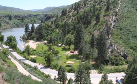
Robie Creek Park is a secluded day use area at the confluence of Mores Creek and Robie Creek on the edge of the Boise National Forest.

Recreation

The lake provides great boating opportunities with Robie Creek Launch Area a short walk away. The park area has a playground and buoyed swimming area.

Facilities

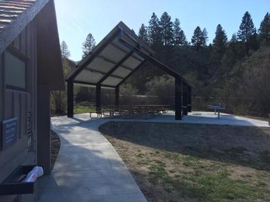
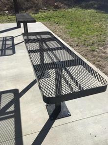
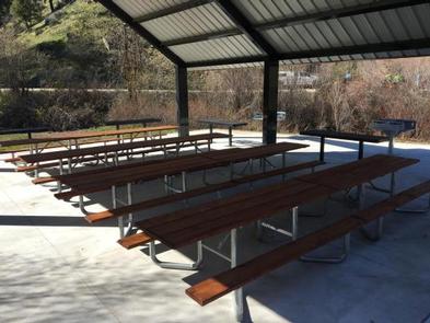
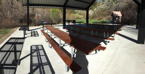
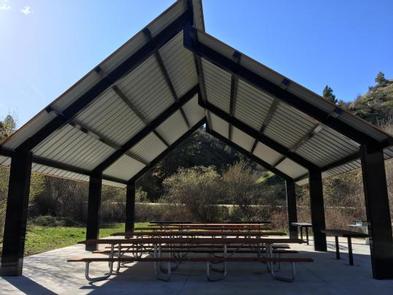
Robie Creek Park has a playground facility, six shade shelters each with a table and stand-up grill, three vault toilets, and one group shelter with 10 picnic tables, high-top serving counters, two large grills and a hot coal bin.

Natural Features

This park is alongside the seasonal Robie Creek in the foothills of the Boise Front. Basalt canyons, ponderosa pines, granite outcrops, and steep loose slopes can be seen from the area.

Reservation

More from CampingHiking.net:

SEVEN POINTS (TN), Tennessee Campground Images, Info & Reservations

Directions From downtown Nashville, TN, take I-40 east for 7 miles and to exit 221B. Turn right onto Old Hickory Boulevard, then left on Bell Road, right on New Hope Road and left on Stewarts Ferry Pike. Follow the signs to the campground. Phone (615)-889-5198 Activities BOATING, CAMPING, FISHING, HIKING,

NOTREBES BEND PARK, Arkansas Campground Images, Info & Reservations

Directions From DeWitt Arkansas, take US-165 south for 8.1 miles. Exit onto State Route 44 east and continue south for 5.3 miles to Tichnor. Take Tichnor Blacktop Road for 10 miles, cross the Arkansas Post Canal Bridge, and turn right onto Wilbur D. Mills Road. Continue for 6.5 miles and

ORLEANS TRAIL, Missouri Campground Images, Info & Reservations

Directions From Stockton, Missouri, take State Highway 39 south approximately 1/2-mile to R.B. Road. Take a left and drive approximately 1/2-mile. Turn right on Blake Street, continue about 1/2-mile, and follow signs to the park area. Phone 417-276-6948 Activities BOATING, CAMPING, FISHING, WILDLIFE VIEWING, SWIMMING SITE Keywords ORLE,STOCKTON LAKE,STOCKTON,SECOND BEACH,STOCKTON

LEIGH CREEK CAMPGROUND, Wyoming Campground Images, Info & Reservations

Directions From Ten Sleep, WY, drive 7.5 miles on Hwy 16 to FSR 018 (WY Hwy 436). Bear right and travel nearly 1 more mile to the campground. Phone 406-587-9054 Activities BIKING, BOATING, CLIMBING, FISHING, HIKING, WILDLIFE VIEWING, HOTEL/LODGE/RESORT PRIVATELY OWNED, OFF ROAD VEHICLE TRAILS, KAYAKING, STAR GAZING, BIRDING, NON-MOTORIZED

SLIDE GROUP AREA, New Mexico Campground Images, Info & Reservations

Directions Located in southeast New Mexico, Slide Group Area is approximately 20 miles east of Alamogordo. From Alamogordo, take Highway 82 east 16 miles. Just before Cloudcroft, turn right (south) on Highway 130, go approximatley 2 miles. Turn right (west) on NM 6563, the Sunspot Highway Go approximately 1/4 miles.