

Directions
Bisti Access Parking
To reach the Bisti Access Parking Area, Drive NM 371 just under 36 miles south of Farmington (from the San Juan River crossing) or just under 45 miles north of Crownpoint (from the intersection of 371 and Navajo Service Route 9), and turn east on Road 7297 (a gravel road). Drive Road 7297 for approximately 2 miles to a T-intersection and turn left. Drive just under one mile to the Bisti Access Parking Area, which is just south of a broad wash on the east side of the road. There is another, smaller parking area 1/4 mile further north.
De-Na-Zin Trailhead
To reach the De-Na-Zin access, Drive NM 371 approximately 43 3/4 miles south of Farmington (from the San Juan River crossing) or approximately 37 1/4 miles north of Crownpoint (from the intersection of 371 and Navajo Service Route 9), and turn east on County Road 7500. Drive approximately 13 1/4 miles on Road 7500 to the De-Na-Zin parking area (on the left side of the road). Alternatively, drive US 550, 4 miles north of NM 57, and turn west onto County Road 7500. Drive approximately 11 1/4 miles to the De-Na-Zin parking area (on the right side of the road). A trail leads from the parking area approximately 3/4 mile to the De-Na-Zin Wash.
Phone
505-564-7600
Activities
CAMPING, HIKING, HORSEBACK RIDING, WILDLIFE VIEWING, PHOTOGRAPHY
Camping Reservations
Reserve your campsite at these camping areas:
Hiking Trails
Looking for nice hiking areas to take a hike? Choose from these scenic hiking trails:
Related Link(s)
More New Mexico Recreation Areas
BLM New Mexico YouTube Channel
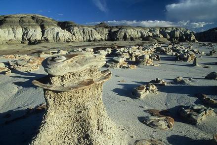
The Bisti/De-Na-Zin Wilderness is a rolling landscape of badlands which offers some of the most unusual scenery found in the Four Corners Region. Time and natural elements have etched a fantasy world of strange rock formations made of interbedded sandstone, shale, mudstone, coal, and silt. The weathering of the sandstone forms hoodoos – weathered rock in the form of pinnacles, spires, cap rocks, and other unusual forms. Fossils occur in this sedimentary landform. Translated from the Navajo language, Bisti (Bis-tie) means “a large area of shale hills.” De-Na-Zin (Deh-nah-zin) takes its name from the Navajo words for “cranes.”