Directions
From Roswell, travel east 45 miles on US 380 and turn south at the sign. From Tatum, travel west 27 miles on US 380.
Phone
575-627-0272
Activities
CAMPING, OFF HIGHWAY VEHICLE, PICNICKING, WILDLIFE VIEWING
Camping Reservations
Reserve your campsite at these camping areas:
Hiking Trails
Looking for nice hiking areas to take a hike? Choose from these scenic hiking trails:
Related Link(s)
More New Mexico Recreation Areas
Mescalero Sands North Dunes OHV Area: Public Lands Web Site
Mescalero Sands North Dune OHV Area
BLM New Mexico YouTube Channel
BLM New Mexico YouTube Channel
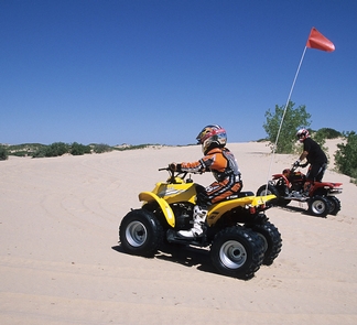
More than 610 acres of towering 90+ foot sand dunes await your enjoyment in the Mescalero Sands North Dune Off-Highway Vehicle (OHV) Area. The dune field stretches over most of the area and lends itself well to all terrain cycles, sand rails and dune buggies. The dunes are made up of quartz particles and are constantly changing due to the prevailing southwest wind. When the dunes are active, they move about a foot per year.
Among the biggest surprises in the area are the mature cottonwood trees. The combination of a very shallow water table and the sand’s capacity to hold water allows these trees to thrive in an arid environment.
While the road into Mescalero Sands is capable of supporting cars, trucks and buses, the soft sand off established roads and parking lots is not. BLM does not recommend leaving the surfaced areas in any vehicle other than an all-terrain vehicle.
The Bowl Parking Area provides access to the northern portion of the dunes, which includes the “Bowl.” The Bowl is a large depression surrounded by dunes. The Cottonwood Site provides access to the southern portion of the dunes. Trails connect both portions of the dunes.


