Directions
Phone
760-252-6000
Activities
HIKING, WILDERNESS
Camping Reservations
Reserve your campsite at these camping areas:
Hiking Trails
Looking for nice hiking areas to take a hike? Choose from these scenic hiking trails:
Related Link(s)
More California Recreation Areas
Overview
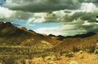
Rugged and volcanic in origin, the Newberry Mountains rise with relative gentleness toward rather broad and flat tops with elevations ranging from 2,200 feet in the north to 5,100 feet in the south.
Deep, mazelike canyons slice through the mountains in all directions. The old Azucar Mine lies just outside the western border, and evidence of past mining activity lies scattershot throughout the area. When the rains cooperate, the western side of the Wilderness erupts into spring wildflower displays. You won’t find much in the way of water or trails in the area. You may see a few desert bighorn sheep passing through, or a falcon or eagle hunting from the air.
For more information about this wilderness, please visit Wilderness Connect.
Leave No Trace
How to follow the seven standard Leave No Trace principles differs in different parts of the country (desert vs. Rocky Mountains). For more information on any of the principles listed below, please visit Leave No Trace, Visit the Leave No Trace, Inc. website.
- Plan Ahead and Prepare
- Travel and Camp on Durable Surfaces
- Dispose of Waste Properly
- Leave What You Find
- Minimize Campfire Impacts
- Respect Wildlife
- Be Considerate of Other Visitors
Rules and Regulations
Motorized equipment and equipment used for mechanical transport are generally prohibited on all federal lands designated as wilderness. This includes the use of motor vehicles (including OHVs), motorboats, motorized equipment, bicycles, hang gliders, wagons, carts, portage wheels, and the landing of aircraft including helicopters, unless provided for in specific legislation. In a few areas some exceptions allowing the use of motorized equipment or mechanical transport are described in the special regulations in effect for a specific area. Contact the agency for more information about regulations.

