Directions
From I-25 take exit 345 on to NM104 heading east. Travel 32.7 miles east to Trujillo, NM. Turn left on to San Miguel County Road C51A at Trujillo and travel east for approximately 7 miles on an improved dirt road. Follow BLM directional signs by turning left at the Y and heading north for 3 miles on the lightly maintained route to the Sabinoso Wilderness parking area. This road is not passable when wet. Please leave gates as you find them.
Phone
575-758-8851
Activities
CAMPING, HIKING, HORSEBACK RIDING, HUNTING, WILDLIFE VIEWING, WILDERNESS
Camping Reservations
Reserve your campsite at these camping areas:
Hiking Trails
Looking for nice hiking areas to take a hike? Choose from these scenic hiking trails:
Related Link(s)
More New Mexico Recreation Areas
BLM New Mexico YouTube Channel
BLM New Mexico YouTube Channel
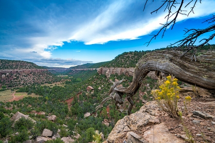
The Sabinoso Wilderness is a remote area in the northeastern portion of New Mexico. The Wilderness includes a series of high, narrow mesas surrounded by cliff-lined canyons. The rugged country primarily supports pi?on pine and juniper woodlands with occasional clusters of ponderosa pine. A perennial warm season grass savanna is found on the mesa tops. Streams periodically flow in the canyon bottoms supporting riparian vegetation including willow and cottonwood. The deep canyon area, surrounded by the wide-open New Mexico plains, is unique for this region. The deep incisions cut by Ca?on Olguin, Ca?on Largo, and Lagartija Creek create a striking topographical and geological contrast in this otherwise flat terrain.


