Directions
From Needles, CA, take I-40 west approx. 10 miles to the U.S. Highway 95 north exit. Exit north and take U.S. Highway 95 approx. 45 miles to NV State Route 164 (Searchlight, NV). Turn left on SR 164 and drive approx. 20 miles to the CA/NV state line. The road turns into Nipton Road. Drive on Nipton Road approx. 15 miles to I-15. Take I-15 north approx. 10 miles to Primm, NV. Exit I-15 and take your first left into Whiskey Pete’s Casino. Drive to the back side of the casino parking lot and exit through the semi-truck parking lot onto BLM Route NN402 – Stateline Pass. Drive approx. 3 miles. A wilderness kiosk sign will be on your left hand side.
Phone
760-326-7000
Activities
HIKING, WILDERNESS
Camping Reservations
Reserve your campsite at these camping areas:
Hiking Trails
Looking for nice hiking areas to take a hike? Choose from these scenic hiking trails:
Related Link(s)
More California Recreation Areas
Stateline Wilderness (Wilderness.net)
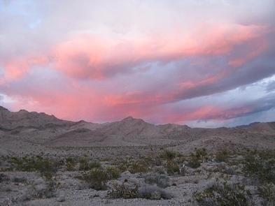
The small but pristine Stateline Wilderness contains the eastern terminus of the 15 mile long Clark Mountain Range. The limestone/dolomite mountains are steep and rugged. Dominant vegetation includes creosote brush and bursage on the bajadas and Mojave yucca, Joshua tree, cacti, and various mixed shrubs on the slopes. The highest elevations contain some pinyon-juniper habitat. Wildlife is typical for the Mojave Desert; including coyote, black-tailed jackrabbits, ground squirrels, kangaroo rats, quail, roadrunners, rattlesnakes, and several species of lizards. The wilderness consists of 6,963 acres.

