Directions
Access Veterans Memorial Highway (599) from either I-25 south of Santa Fe (exit 282) or off of Saint Frances Drive, NW. Exit onto Camino La Tierra road heading west toward the Rio Grande. After about 4 miles, take a right onto Old Buckman Road and start down a dirt road. After about 7.5 miles, you will reach the turnoff on your left used for parking for the Diablo Canyon Recreation Area.
Phone
575-758-8851
Activities
CLIMBING, CAMPING, HIKING
Camping Reservations
Reserve your campsite at these camping areas:
Hiking Trails
Looking for nice hiking areas to take a hike? Choose from these scenic hiking trails:
Related Link(s)
More New Mexico Recreation Areas
BLM New Mexico YouTube Channel
BLM New Mexico YouTube Channel
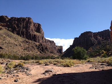
The dramatic vertical cliffs of Diablo Canyon Recreation Area make the area a hiking and climbing destination near the Rio Grande. The eastern cliff walls are on BLM-managed land and the western cliff walls are managed by the U.S. Forest Service. Diablo Canyon has been featured in movies such as The Missing, 3:10 to Yuma, and Cowboys and Aliens.
The cracked basalt of Diablo Canyon offers some of the best multi-pitch tradition and sport climbing in New Mexico. Over one hundred routes range from 5.8 to 5.13 in difficulty. Winter Wall and the Solar Cave are located on the east side of the canyon.

