Directions
Interstate 15, Exit 16 to Hwy 9, turn left onto Kolob Terrace Rd/Pocketville Rd in Virgin, turn left onto Smith Mesa Rd until you hit wilderness.
Phone
435-688-3200
Camping Reservations
Reserve your campsite at these camping areas:
Hiking Trails
Looking for nice hiking areas to take a hike? Choose from these scenic hiking trails:
Related Link(s)
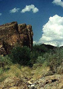
Comprised of approximately 1,500 acres, the Red Butte Wilderness includes vibrantly hued sandstone spires and domes, narrow slot canyons, and forested mesa tops of pinyon pine and Utah juniper. Found along the southwest corner of Zion National Park, the wilderness area shares a .75 mile border with the park. The western side of the wilderness area incorporates a portion of the Lower Kolob Plateau, which offers the closest vehicle access route. A high degree of solitude can be experienced in the Red Butte Wilderness, as well as many scenic vistas. The upper reach of Smith Creek, designated as wild in the National Wild and Scenic Rivers System lies within the northwest corner of this wilderness. Only a third of a mile long, the steam channel is moderately sloped and heavily vegetated. Elevation within the wilderness area ranges from a high of 7,400 feet to a low of 5,600 feet. The diverse topography supports many wildlife species. A great benefit to wildlife is the large expanse of wildland that is formed by this wilderness area, other contiguous BLM managed lands, and the contiguous lands in Zion National Park.


