Directions
Entry into the area is best gained by turning westward from US 550 onto County Road 279 approximately 20 miles northwest of San Ysidro. A green highway sign (labeled San Luis, Cabezon) marks the turnoff. Continue 12 miles (south-west past the village of San Luis) to the Cabezon turn-off onto BLM Road 1114. The pavement ends just beyond San Luis.
At the intersection of CR 279 and BLM Road 1114, you will pass by the ghost town of Cabezon. Follow BLM Road 1114 for 2.9 miles to the dirt route that leads east to the trailhead.
Travel on CR 279 and BLM Road 1114 is good during dry conditions. During the rainy season, normally in spring and late summer, the roads can get slippery and rutted. During winter, the area can be unreachable. Check with the BLM about road conditions before your visit. Use of this area is regulated only to the extent needed to protect the resources and ensure your safety.
Phone
505-761-8700
Activities
CLIMBING, CAMPING, HIKING, HUNTING
Camping Reservations
Reserve your campsite at these camping areas:
Hiking Trails
Looking for nice hiking areas to take a hike? Choose from these scenic hiking trails:
Related Link(s)
More New Mexico Recreation Areas
BLM New Mexico YouTube Channel
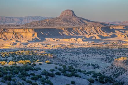
The Cabezon WSA is located in the northwestern part of the New Mexico and consists of a large volcanic plug – a steep-sided symmetrical neck of volcanic rock. At an elevation of 7,785 feet, this is the largest of a series of volcanic plugs in this area and is one of the most well-known landmarks in northwest New Mexico. This peak is a favorite among climbers. Basic mountain climbing experience and proper gear, including a helmet, are needed, but most will not choose to use a rope on the common route. A successful climb to the summit will reward you with an expansive view of the Rio Puerco Valley.