Directions
The reservoir is located 20 miles south of Vermillion on UT 24.
Phone
435-896-1500
Activities
CAMPING, FISHING, HIKING, OFF HIGHWAY VEHICLE
Camping Reservations
Reserve your campsite at these camping areas:
Hiking Trails
Looking for nice hiking areas to take a hike? Choose from these scenic hiking trails:
Related Link(s)
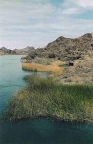
Koosharem Reservoir is located at 6995 ft. The reservoir is at one end of the justly popular Paiute ATV trail. For those who wish to pursue more contemplative activities, the reservoir is stocked with trout, and there is trail access into the Fishlake National Forest.
Koosharem Reservoir is a small shallow lake formed by damming Otter Creek above Grass Valley. The reservoir shoreline is privately/publicly owned and administered by the BLM and the Koosharem Irrigation Company with public access. The water level fluctuates seasonally and has a Surface Area of 310 acres. The reservoirsits at 6,995 ft. and has a max depth of 20 ft. Fishing at Koosharem can be a year round activity. Past surveys found that cutthroat and rainbow trout are showing better growth and condition than in past years. Tackle should imitate chubs: rapalas, lures, large streamers. Cut bait or frozen minnows are also worth a try. This reservoir not only has good fishing, but also offers access to the Paiute ATV trail. OHVers can explore almost 3000 miles of famous scenic trail that traverse mountain tops and rugged canyons. Facilities at the reservoir are limited to day use only, but there are ADA accessible toilets, picnic tables, and a picnic grill available.


