Directions
Site is south of Auberry, California off State Highway 168.
Phone
916-985-4474
Activities
BIKING, CLIMBING, HISTORIC & CULTURAL SITE, CAMPING, INTERPRETIVE PROGRAMS, FISHING, HIKING, PICNICKING, WILDLIFE VIEWING
Camping Reservations
Reserve your campsite at these camping areas:
Hiking Trails
Looking for nice hiking areas to take a hike? Choose from these scenic hiking trails:
Related Link(s)
More California Recreation Areas
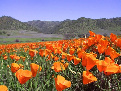
The Squaw Leap Area is located at the upper portion of Millerton Lake and is accessed through the town of Auberry, CA. The area is managed by BLM with trail heads for the San Joaquin trail. The trail leads through chaparral uplands with mountain lilac, manzanita, mahogany and many shrubs and annual wildflowers. The trails leading from Squaw Leap Area include a 6 mile loop through the northern portion of the recreation area and a 4 mile trail connecting to the San Joaquin River Trail. Interpretive nature trails and cultural information is available. BLM cooperates with the California Parks and Recreation at Millerton Lake to help users appreciate the foothills area of the Sierra Nevada. Access to the lake and river areas provide good shore fishing opportunities.