Directions
From Walden: Take Highway 14 west for approximately 11 miles to Hebron. Turn right on County Road 24 driving west. After approximately 10 miles the road becomes Forest Road 60 and passes the Grizzly Creek Guard Station. Turn right on Forest Road 615. Drive approximately 3 miles and turn right into the Teal Lake Campground.
Phone
970-723-2700
Activities
CAMPING, FISHING, PICNICKING, WILDLIFE VIEWING
Keywords
TEAL,MEDICINE BOW-ROUTT NF-FS
Related Link(s)
Colorado State Road Conditions
Overview
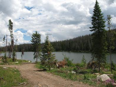
Teal Lake Group Campground is set along a small yet scenic lake in north central Colorado in the heart of the Rocky Mountains. Located in the Routt National Forest at an elevation of 9,000-ft., the lake is popular for trout fishing and lies close to a wilderness area with a variety of hiking and off-highway vehicle trails.
Recreation
Trout fishing and boating are popular activities in the clear, calm waters of Teal Lake. Only electric boats and non-motorized boats are permitted. Off-road vehicle enthusiasts have easy access to the Grizzly-Helena Trail nearby.
Hiking is great in the nearby Mount Zirkel wilderness, though hikers must drive to the trailheads.
Facilities
Teal Lake provides 17 individual campsites and one group site for up to 30 people. Campsites are private and have ample space. The group site has four picnic tables and two campfire rings for groups to gather.
Natural Features
Teal Lake is a 50-acre lake surrounded by a rocky shoreline and pine-fir forest. Some previously forested areas of the campground have been thinned due to pests and thus have more sun than others.
Black bear, bobcat, coyote, elk, mule deer and moose are just some of the many animals that inhabit the Medicine Bow-Routt National Forests and Thunder Basin National Grassland.
The area is generally snow-free from Memorial Day to Labor Day, but visitors should come prepared for anything, including freezing temperatures and snow during summer.
Nearby Attractions
The closest town is Walden, Colorado. Many more outdoor opportunities exist in the nearly 3 million acres of surrounding national forests and grasslands, including hiking, biking, camping, horseback riding, OHV riding, fishing, hunting, sightseeing and winter sports.

