AMITY RECREATION AREA, GA Campground Reservation, Info, Images, Map, Directions

AMITY RECREATION AREA, Georgia Campground Images, Info & Reservations

Directions

From Thomson, Georgia, take U.S. Highway 78 west for 6 miles. Turn right on State Route 43 and continue for about 7.5 miles. The park is on the right (look for signs). The park is located on the McDuffie/Lincoln County line.

Phone

800-533-3478

Activities

BOATING, FISHING, PICNICKING, WILDLIFE VIEWING, SWIMMING SITE, SOFTBALL FIELDS

Keywords

AMI2,J STROM THURMOND LAKE

Related Link(s)

Rec Area Info & Images

Georgia State Road Conditions

Georgia State Tourism

Overview

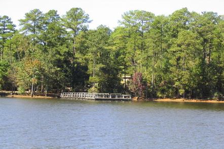
Amity Recreation Area is one of the most popular parks on J. Strom Thurmond Lake. The large, 70,000-acre lake and its 1,000 miles of shoreline provide excellent boating, water skiing, swimming, fishing, hiking and picnicking.

Recreation

Thurmond Lake provides some of the best fishing, hunting and water sports in the southeastern United States.

Anglers will find largemouth bass, bream, crappie, catfish and striped bass. The large lake offers endless boating, waterskiing, jet skiing, canoeing and swimming opportunities. Amity Recreation Area provides a boat ramp and swimming area.

Facilities

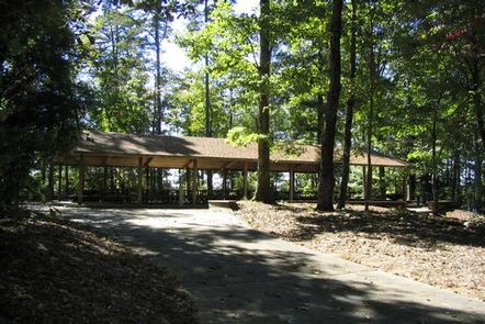
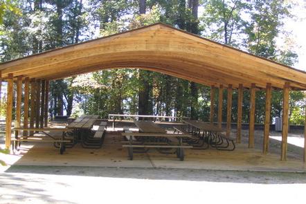
This facility is a wooded day-use area on the lake shore. There are three reservable group picnic shelters that can each accommodate up to 92 guests. A boat ramp, fishing pier, swimming area, ball field and playground provide additional recreation opportunities.

Natural Features

Hot, humid summers and mild, pleasant winters characterize this wooded area. A mixed pine and hardwood forest covers the site, providing summer shade and fall color.

Wildlife is abundant around the lake. Visitors might spot bald eagles, migratory waterfowl, osprey, wild turkeys and white-tailed deer.

Nearby Attractions

Augusta, Georgia, about 20 miles away, offers museums, art galleries, zoos, restaurants and shopping areas. The Augusta National Golf Club hosts the Masters Golf Tournament annually the first week of April.

Reservation

More from CampingHiking.net:

FOX CREEK CABIN (MT), Montana Campground Images, Info & Reservations

Directions There is no motorized access to this cabin. There are two travel options to Fox Creek Cabin: 1. South Cottonwood Trailhead. From Bozeman, MT: Drive south on S. Cottonwood Road for about 7 1/2 miles. Turn left onto Cottonwood Canyon Road and drive about 2.1 miles to the end

COTTONWOOD (NE), South Dakota Campground Images, Info & Reservations

Directions From U.S. Hwy 81 in Yankton, South Dakota, drive four miles west on South Dakota Highway 52, then south on Dam Toe Road and follow signs. Phone 402-667-2546. FOR RESERVATIONS, CALL 877-444-6777. Activities BIKING, BOATING, CAMPING, FISHING, HIKING, PICNICKING, WILDLIFE VIEWING, DAY USE AREA, PLAYGROUND PARK SPECIALIZED SPORT SITE,

FURNACE CREEK, California Campground Images, Info & Reservations

Directions Death Valley is in eastern California on the Nevada border, 130 miles west-northwest of Las Vegas, Nevada and 106 miles east of Lone Pine, California. Furnace Creek Campground is a half-mile north of Furnace Creek Visitor Center on State Highway 190. Phone 760-786-2441 Activities BIKING, HISTORIC & CULTURAL SITE,

TAHKENITCH CAMPGROUND, Oregon Campground Images, Info & Reservations

Directions From Reedsport, drive north 7.5 miles on Highway 101. Campground is on the west (left) side of Highway 101. Phone 541-271-6000 Activities BOATING, CAMPING, FISHING, WILDLIFE VIEWING, SWIMMING SITE, BIRDING Keywords TAHK,OREGON DUNES,SIUSLAW NF – FS Related Link(s) Rec Area Info & Images Oregon State Road Conditions Oregon State

OUTLET AT PRIEST LAKE, Idaho Campground Images, Info & Reservations

Directions Physical Address: Priest River, ID 83856 From I-90; Turn at Post Falls Highway 41 north to Newport, WA. Take Highway 2 east to Priest River. At the junction of Highway 57 and Highway 2, turn left. Drive 26 miles to Outlet Bay Road. Turn right for approximately 0.5 mile.