GILL POINT, SC Campground Reservation, Info, Images, Map, Directions

GILL POINT, South Carolina Campground Images, Info & Reservations

Listen

Directions

From Lincolnton, GA, travel approximately 12 miles north on SR-79.

Phone

800-5333478

Activities

BOATING, DAY USE AREA, SWIMMING SITE, ACCESSIBLE SWIMMING

Keywords

GILL,J STROM THURMOND LAKE

Related Link(s)

Rec Area Info & Images

Georgia State Tourism

Georgia State Road Conditions

Overview

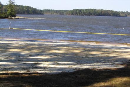
Gill Point Recreation Area is a rural park on the northern end of J. Strom Thurmond Lake, off Georgia State Highway 79. The 70,000 acre lake and its 1,000+ miles of shoreline provide excellent boating, water skiing, swimming, fishing, hiking and picnicking opportunities.

Recreation

Thurmond Lake provides some of the best fishing, hunting, and water sports in the southeastern United States. Anglers fish for largemouth bass, bream, crappie, catfish and striped bass. The large lake offers endless boating, water skiing, jet skiing, canoeing and swimming opportunities.

Facilities

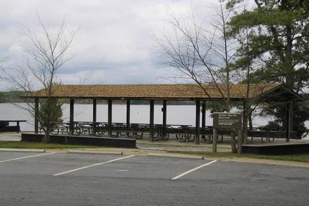
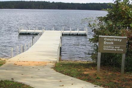
Gill Point Recreation Area is a wooded day-use area with a group picnic shelter that can accommodate up to 24 people. Amenities include flush toilets, drinking water, a boat ramp and dock.

Natural Features

Hot, humid summers and mild, pleasant winters characterize this heavily wooded area on the shore of Thurmond Lake. A mixed pine and hardwood forest covers the site, providing summer shade and fall color. Elevation is 335′ above sea level.

Wildlife is abundant around the lake. Visitors regularly see southern bald eagles, migratory waterfowl, wild turkeys and whitetail deer.

Nearby Attractions

This quiet, rural area is very historic. The now-flooded town of Petersburg and the Nancy Hart Historical Site in Elbert County are nearby. The campground is 20 miles southeast of Elberton, Georgia, known as the Granite Capital of the World.

Numerous parks and recreation areas lie around Thurmond Lake, providing additional boating, swimming, hunting, and hiking opportunities. Nearby cities house museums, art galleries, zoos, restaurants, and shopping areas.

The Augusta National Golf Club hosts the Masters Golf Tournament annually the first week of April.

Reservation

More from CampingHiking.net:

FRUITA CAMPGROUND, Utah Campground Images, Info & Reservations

Listen Directions Traveling westbound on Interstate 70: Take Utah State Highway 24 west towards Hanksville (exit 149). Stay on Highway 24 for 80 miles to reach the park Visitor Center. Traveling on Interstate 15: Take US Highway 50 east at Scipio (exit 188) towards Salina for 30 miles. At the

SUNSET CAMPGROUND (CA), California Campground Images, Info & Reservations

Listen Directions Kings Canyon National Park is easily accessible from Fresno, California. Take HWY 180 East from Fresno, and proceed 55 miles to Kings Canyon National Park. Three miles east of the Big Stump Entrance Station you will find Sunset campground on your left. Phone 559-565-3341 Activities BIKING, CAMPING, INTERPRETIVE

PORCUPINE (ID), Utah Campground Images, Info & Reservations

Listen Directions From U.S. Highway 89, turn west onto St. Charles Canyon Road/Forest Road 412. Follow for approximately 7 miles to the campground on the left side of the road. Phone 541-351-1182 Activities BIKING, BOATING, HISTORIC & CULTURAL SITE, CAMPING, FISHING, HIKING, HORSEBACK RIDING, HUNTING, WATER SPORTS, WILDLIFE VIEWING, SWIMMING

GREEN RIVER CAMPGROUND, Utah Campground Images, Info & Reservations

Listen Directions Green River Campground is located approximately 12 miles north of US Highway 40. Take Utah State Route 149 from Jensen, Utah. Phone 435-781-7700 Activities BIKING, CAMPING, INTERPRETIVE PROGRAMS, FISHING, HIKING, WILDLIFE VIEWING, EVENING PROGRAMS Keywords GREEN RIVER CAMPGROUND,GREEN RIVER,DNM Related Link(s) Rec Area Info & Images Utah State

ROARING RIVER (GROUP), Oregon Campground Images, Info & Reservations

Listen Directions From Eugene, Oregon, take I-105 east to McKenzie Highway 126 just past Milepost 45. Turn South on Aufderheide Drive/Forest Service Road 19 and travel for 22 miles to campground. Entry is through a locked gate with a combination. Phone 541-822-3381 Activities CAMPING, FISHING Keywords ROAR,WILLAMETTE NF -FS Related

RIVERSIDE (OR), Oregon Campground Images, Info & Reservations

Listen Directions From Estacada, travel east on Highway 224 for approximately 26 miles, then keep right onto Highway 46 for approximately 2 miles to the campground. Phone 503-630-5721 Activities BIKING, CAMPING, FISHING, HIKING, WATER SPORTS, WILDLIFE VIEWING Keywords RIVX,MT. HOOD NF – FS Related Link(s) Rec Area Info & Images